Introduction
Riverville is a fictional town with a real
problem. Each week, more citizens are
complaining that their drinking water tastes
bad. In many small towns like this one, there is
no central water supply. Every home and most businesses have
a private well. The town's mayor tested the water from
several wells and found that the ground water has been
contaminated with some kind of fuel. The wells that have
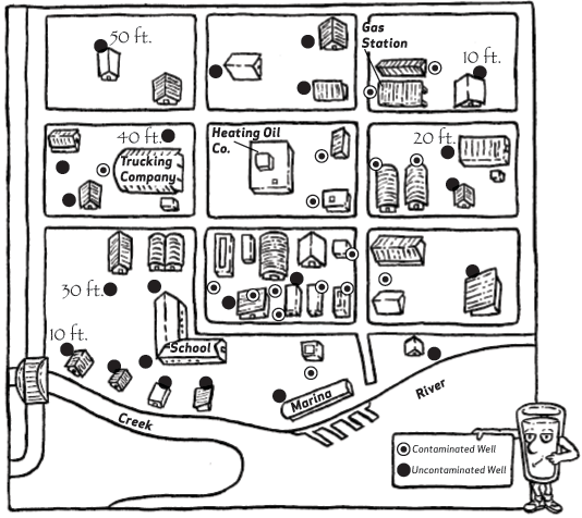
been contaminated are marked out on the map below.
The mayor thinks the Heating Oil
Company is responsible for this contamination
and wants them to start investigating their
fuel storage tanks which are buried underground and
to check the tanks for leaks. The Heating Oil Co. says they
just tested their tanks and know they are safe. They think
the Trucking Company is the source of pollution. The Trucking
Co. says the source could just as likely be the Heating
Oil Co. or the Gas Station, since all three places have
underground tanks for storing the same kind of fuel.
So Riverville has a problem and no
one is sure who is responsible. The mayor
needs some way of proving who is causing the
pollution and who should clean it up. You will be
the "detective" who helps prove where the pollutant is coming from. Cleaning up ground water
contamination is a very expensive job. You
should be very sure of the place you choose to
start cleaning up, otherwise the money will be wasted. It
is up to you to solve the mystery.
Objective
You will make a
topographic map, use it to predict ground water
flow and investigate the most likely source of ground
water contamination.
General Procedures
To decide which of
the suspected businesses is the most likely
source of contamination, the easiest thing you can do
is find out the direction that ground water flows. Since ground
water generally flows downhill, following the slope of
the surface of the land, you can be fairly certain that the suspected
source which is farthest "upstream" is the real source
of contamination.
This activity
shows you how to estimate ground water flow by
making a contour map.
As in many very small towns, only
a few people in Riverville know the exact elevation above
sea level for their property. To make a contour map, it
usually helps to know the elevations of as many places as
possible. But this simple procedure can be used even though
you only know a few elevations.
The map shows
the elevations for seven wells and gives directions
for drawing in the contours of the land. After you
have finished this procedure, answer the questions below.
Questions
- If the flow of
ground water and the pollutants in it follow the
contour of the land, what is the mostly likely source
of the contamination, the Heating Oil Co., the Trucking
Co. or the Gas Station?
- The
contamination plume will continue to spread slowly through
the ground, much like smoke from a chimney drifting into
the wind. Describe where on your map you think the
plume will move with time.
- Which of the
uncontaminated wells do you expect to become
contaminated in the near future? Do you think the school's
water well will be contaminated?
- How do you
explain the fact that one well within the plume
was not contaminated?
- Is it
possible you are wrong in assuming that ground water
flow follows the contour of the land? What else could
you investigate to be sure?
- Assuming that
ground water flow does follow the contours of
the land, is it possible that there are two sources of
contamination? What would you expect to find if all three
companies had leaking storage tanks and were actual sources
of contamination?
Extentions
- Get a map of your
own community and use it to chart out ground
water direction. Locate the community's water supply
and any potential sources of contamination. What kind
of precautions should be taken to keep an eye on potential
sources of contamination?
Activity

CLICK
HERE TO DOWNLOAD A LARGER VERSION OF THIS GRAPHIC (84 K GIF FILE)
- Start
with a well with a known elevation. Using ruler and pencil,
LIGHTLY draw a line from this well to the nearest wells
having at least a 20-foot difference in elevation.
- Cut a
rubber band open and lay it out flat, without stretching
it, along the edge of a ruler. With a pen, make at least
five marks ½ inch apart beginning from the middle of the
rubber band. Use the marked rubber band to help you divide
each line into equal segments.
- Label
each mark on the line between the known elevations with
the estimated elevations. For example, if the elevations
at each end of the line are 10 and 40 feet above sea
level, you should make two marks on the line, dividing the
line into three equal lengths. The first mark should be labeled
20 and the next one labeled 30.
- Connect
all marks having the same elevation with a smooth
line. These are contour lines.
- Every
half inch or so along each contour line, draw a short
arrow perpendicular from one line out towards the line
having the next lowest elevation. Ground water flows in
the direction of the arrows.
- Find
all the contaminated wells and draw a single loop that
contains only these wells, if possible. The area inside this
loop shows how far the contamination has already spread
through the ground water, and is called the contamination plume.
- Use
your map to answer questions above.
Download PDF VERSION: (237 K PDF FILE, 2 pgs)
|

