 Border Air Quality Data - Brownsville/Laredo Area Monitoring Sites
The map below indicates the locations of air monitoring sites in the Brownsville/Laredo area of the U.S.-Mexico border. The table following the map gives the address of each site and the criteria air pollutants measured there.
Map of Brownsville/Laredo area
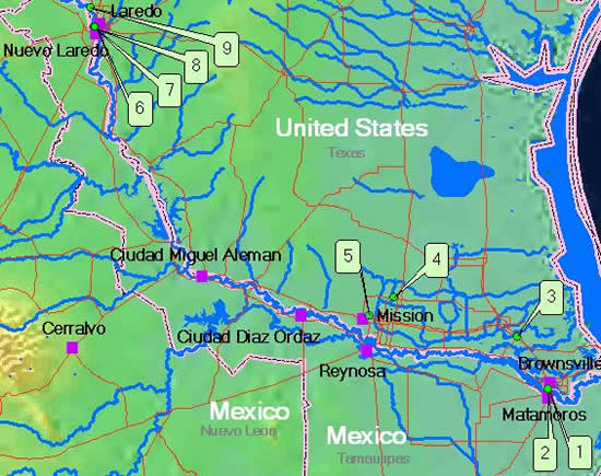
Air monitoring sites in Brownsville/Laredo area
| Map ID | AQS Site ID | Address | County, State | Pollutants Measured |
|---|---|---|---|---|
| 1 | 480610004 | Gladys Porter Zoo At 6th & Ringold, Brownsville | Cameron, TX | PM10 |
| 2 | 480610006 | 344 Porter Drive, Brownsville | Cameron, TX | CO, O3, SO2, PM2.5, PM10, Pb, HAPs |
| 3 | 480612002 | 195 Adele Street, San Benito | Cameron, TX | PM2.5, PM10 |
| 4 | 482150042 | 1902 West Schunior, Edinburg | Hidalgo, TX | O3, PM2.5, HAPs |
| 5 | 482150043 | 2300 North Glasscock, Mission | Hidalgo, TX | O3, PM2.5, PM10, HAPs |
| 6 | 484790015 | Laredo Junior College, Laredo | Webb, TX | PM10 |
| 7 | 484790016 | West End Washington St., Laredo | Webb, TX | CO, O3, PM2.5, PM10, Pb, HAPs |
| 8 | 484790017 | 700 Zaragosa St., Laredo | Webb, TX | CO, PM2.5, PM10, HAPs |
| 9 | 484790313 | Mines Road 11601 Fm 1472, Laredo | Webb, TX | PM2.5 |