STORET Central Warehouse
STORET
Warehouse Help
Overview of System
STORET Warehouse
Application
Station Report
Stations
by Geographic Location
Stations
by Organization and Station ID
Stations
by Organization and Project ID
Result Reports
Regular
Result Report
Biological
Result Report
Habitat
Result Report
Metric
Result Report
Index
Result Report
Results
by Geographic Location
Results by Organization and Station ID
Results by Organization and Project ID
Selection
Criteria for Result and Station Reports
Geographic
Location Selection Overview
Date Range Selection
Characteristic
Selection
Activity Medium
Selection
Activity Intent
and Community Sampled Selection
Organization/Station
Selection
Organization/Project
Selection
Station Type Selection
Organization Selection
Administrative Filters Selection
Characteristic Selection
Characteristic Group Type Selection
EXCLUDE Report Count(s): (Optional)
Summary Pages
Station Search Summary
Page
Number
of Stations Returned
Search
Parameter Values Summary
Navigation
Options for Stations
Report
Customization for Stations (Select Data Elements for Report)
Station Group
Elements
#13: Spring
Info
#21: Latitude/Longitude
#24: Conv Latitude/Longitude
#27: Lat/Long
Info
#29: Elevation (w/ Units)
(w/ Units)
#31: Additional
Elevation Info
#33: Country
Name
#40: RF1
Info
#45: Estuary
Info
#56: Well Hole Depth Measure
#58: Station Document/Graphic
#62: Administrative Submission/Change Record
Station Data Elements
Result Search Summary
Page
Number of
Results Returned
Search Criteria
for Results
Navigation
Options for Results
Report
Customization for Results (Select Data Elements for Report)
Result Group Elements
#6: Station
Location Info
#10: Station
Lat/Long
#13: Conv Station
Lat/Long
#16: Station
Types
#20: Visit
Start
#22: Visit
Stop
#27: Activity
Start
#29: Activity
Stop
#43: Actual Activity
Lat/Long
#47: Conv Actual Activity
Lat/Long
#53: Additional
Act Location Info
#65: Sample
Preservation
#70: Characteristic Name
#78: Result Value as Text
#84: Activity/Result Comment
#95: Additional
Anal Proc Info
#105: Other
Lab Info
#115: Data Quality
#119: Activity/Result Document/Graphic
#123: Net
Tow Info
#149: Electroshock
Info
#157: Net
Non-Tow Info
#165: General
Group Info
#169: Multi-Taxon
Pop Census Info
#178: Single
Taxon Frequency Class Info
#187: Single
Taxon Individual Info
#189: Collection Duration Info
#191: Reach Measure
#193: Toxicity Test Type
Result Depth Height
#198: Bio Individual
#199: Unidentified Species ID
#200: Group Summary Count Weight
#201: Frequency Class
#202: Laboratory Accreditation Indicator
#205: Lab Sample Preparation ID
#206: Lab Sample Prep Info
#232: Administrative Submission/Change Record
Regular
Result Data Elements
Biological
Result Data Elements
Habitat
Result Data Elements
Watershed Summary
Get Organization Summary and Download Results for One/All organizations
Get Characteristic Type Summary and Download Results for Selected Characteristic Types
Download Results Page
Download
Results Page General
Explanation
of Result Report Format
Download
Site Descriptions Page
Download
Site Descriptions Page General
Explanation
of Station Report Format
Download Your Compressed Data File
Retrieving
Documents/Graphics
Glossary
Overview of System
You are preparing to extract data from EPA's Modernized STORET Data
Warehouse. Data here have been provided to EPA through the voluntary
contributions of many States, Federal Agencies, local organizations, Native
American Tribes, volunteer groups, and other interested organizations.
All data kept on this web site is fully documented with respect to field
and laboratory methods employed, monitoring technologies used, project
goals and plans, and QA/QC practices of the submitting organizations.
Questions concerning the specific data of any organization are best directed
to the organization from which the data were obtained.
EPA makes no warranty regarding the accuracy of the environmental data
stored here.
There are no fees or charges associated with the use of this site.
The data on this web site are broken down into two major categories
and they are Stations and Results. The Station area has the
selection options of Stations by Geographic Location and Stations by Organization and Station ID. There are three
groupings of Results: Regular, which are non-biological physical
and chemical results, Biological, and Habitat. Within each of these
Result areas you have the option to select Results by Geographic Location,
Results by Stations, or Results by Project. Each one of these possible
selections has a search criteria screen where you can streamline their
query.
For the Stations by Geographic Location option you will have the option to specify the
type of data you want on your report or your search criteria. The search criteria
options are organized into several groups. They are: Geographic Location, Station Types, Characteristics,
and Organizations. The available search criteria are:
For the Stations by Organization and Station ID option you will have the option to specify the
type of data you want on your report or your search criteria. The search criteria
options are organized into several groups. They are: Organization/Station ID, Station Types, and Characteristics.
The available search criteria are:
For each of the Result groupings there is a Results by Geographic
Location option. For this option you will be able to specify the
type of data you want on your report. The search criteria options are organized into several groups.
They are: Geographic Location, Date Ranges,
and Characteristics. In
addition, for a Regular Results report one can select an Activity Medium
and for a Biological Results report one can select Activity Intent and
Community Sampled combination. The available search criteria are:
For each of the Result groupings there is a Results by Station option.
For this option you will be able to specify the
type of data you want on your report. The search criteria options are organized
into several groups. They are: Organization/Station, Date Ranges, and
Characteristics. In addition, for a Regular Results report one can select
an Activity Medium and for a Biological Results report one can select Activity Intent and Community
Sampled combination. The available search criteria are:
For each of the Result groupings there is a Results by Project option.
For this option you will be able to specify the
type of data you want on your report. The search criteria options are organized
into several groups. They are: Organization/Project, Date Ranges and Characteristics.
In addition, for a Regular Results report one can select an Activity Medium and for
a Biological Results report one can select Activity Intent and Community
Sampled combination. The available search criteria are:
Top
STORET Warehouse
Application
Station Report
Stations
by Geographic Location
The Stations by Geographic Location page allows you to specify the selection
criteria for your Station search. There are four different selection
criteria areas:
Geographic
Location Selection,
Station Type
Selection,
Characteristic Selection,
and Organization Selection.
Within each of the selection areas, you may accept the default values or
enter/choose specific values as your search criteria. After you have
entered all of your selection criteria, click on the <Continue>
button to perform the Station Search and proceed to the next page.
To reset all search criteria to default values, click on the <Clear
Form> button.
Stations
by Organization and Station ID
The Stations by Organization and Station ID page allows you to specify the selection
criteria for your Station search. There are three different selection
criteria areas:
Organization/Station Selection,
Station Type
Selection, and
Characteristic Selection.
Within each of the selection areas, you may accept the default values or
enter/choose specific values as your search criteria. After you have
entered all of your selection criteria, click on the <Continue>
button to perform the Station Search and proceed to the next page.
To reset all search criteria to default values, click on the <Clear
Form> button.
Stations by Organization and Project ID
The Stations by Project page allows you to search for Results using
these selection criteria areas for the three Result Reports (Regular, Biological, Habitat, Metric, and Index Results
): Organization/Project
Selection,Station Type Selection,
Date Range Selection,
and Characteristic Selection.
For the Regular Result report you can also search for Results using Activity
Medium Selection. For the Biological Result there is an additional search
for Activity Intent and Community
Sampled Selection combinations. Within each of the selection areas, you
may accept the default values or enter/choose specific values as your search
criteria. After you have entered all of your selection criteria,
click on the <Continue> button to perform the Result Search and
proceed to the next page. To reset all search criteria to default
values, click on the <Clear Form> button.
*EXCLUDE Report Count(s): (Optional)
By Definition:
The EXCLUDE ("include the inverse") Option acts to prevent specific report types from the Summary Counts or taking part in an the Summary Counts of a result set. It ensures that any checked data report types are NOT returned for download. UNCHECKED Report Types will apply all applicable query filters. The EXCLUDE Option allows the data requester to only return specific report types. Due to record request limitation, data request for batch processing are limited. Request exceeding maximum limits require additional filters and re-submission to satisfy record limits.
Report Type Customization for Summary (Using the EXCLUDE Option):
REGULAR only: (check all boxes except REGULAR)
BIOLOGICAL only: (check all boxes except BIOLOGICAL)
HABITAT only: (check all boxes except HABITAT)
METRIC only: (check all boxes except METRIC)
INDEX only: (check all boxes except INDEX)
etc...
*Exclude Parameter(s):
By Definition:
The EXCLUDE Option performs or applies the INVERSE of the selected parameters..
1. to leave out (selected) : to not include (selected) parameters.
Result Reports
There are three categories of Result reports. There is the Regular
Result Report, the Biological Result Report, and the Habitat Result Report.
The Regular Result Report retrieves non-biological physical and chemical
data. The Biological Result Report and the Habitat Result Report
retrieve biological and habitat data respectively.
Regular Result Report
The Regular Result Report consists of non-biological physical and chemical
results data only. Like the other two Result report pages, there
are three selection criteria pages and they are Results by Geographic Location,
Results by Station, and Results by Project. The information on these
pages is based on your specified selections. For each of these
pages you can narrow the scope by selecting specific criteria.
Each page provides Date Range and Characteristic selections. The
other selection criteria are specific for each page.
Biological Result
Report
The Biological Result Report consists of biological data only.
Like the other two Result report pages, there are three selection criteria
pages and they are Results by Geographic Location, Results by Station,
and Results by Project. The information on these pages is based on your
specified selections. For each of these pages you can
narrow the scope by selecting specific criteria. Each page provides
Date Range and Characteristic selections. The other selection criteria
are specific for each page.
Habitat Result Report
The Habitat Result Report consists of habitat data only. Like
the other two Result report pages, there are three selection criteria pages
and they are Results by Geographic Location, Results by Station, and Results
by Project. The information on these pages is based on your
specified selections. For each of these pages you can narrow
the scope by selecting specific criteria. Each page provides Date
Range and Characteristic selections. The other selection criteria
are specific for each page.
Results
by Geographic Location
The Results by Geographic Location page allows you to search for Results
using these selection criteria areas for the three Result Reports (Regular,
Biological, and Habitat Results): Geographic
Location Selection,Station Type Selection,
Date Range Selection,
and Characteristic Selection.
For the Regular Result report you can also search for Results using Activity
Medium Selection. For the Biological Result there is an additional search
for Activity Intent and Community
Sampled Selection combinations. Within each of the selection areas, you
may accept the default values or enter/choose specific values as your search
criteria. After you have entered all of your selection criteria,
click on the <Continue> button to perform the Result Search and
proceed to the next page. To reset all search criteria to default
values, click on the <Clear Form> button.
Results by Organization and Station ID
The Results by Station page allows you to search for Results using
these selection criteria areas for the three Result Reports (Regular, Biological, Habitat, Metric, and Index Results
): Organization/Station
Selection,Date Range Selection,
and Characteristic Selection.
For the Regular Result report you can also search for Results using Activity
Medium Selection. For the Biological Result there is an additional search
for Activity Intent and Community
Sampled Selection combinations. Within each of the selection areas, you
may accept the default values or enter/choose specific values as your search
criteria. After you have entered all of your selection criteria,
click on the <Continue> button to perform the Result Search and
proceed to the next page. To reset all search criteria to default
values, click on the <Clear Form> button.
Results by Organization and Project ID
The Results by Project page allows you to search for Results using
these selection criteria areas for the three Result Reports (Regular, Biological, Habitat, Metric, and Index Results
): Organization/Project
Selection,Station Type Selection,
Date Range Selection,
and Characteristic Selection.
For the Regular Result report you can also search for Results using Activity
Medium Selection. For the Biological Result there is an additional search
for Activity Intent and Community
Sampled Selection combinations. Within each of the selection areas, you
may accept the default values or enter/choose specific values as your search
criteria. After you have entered all of your selection criteria,
click on the <Continue> button to perform the Result Search and
proceed to the next page. To reset all search criteria to default
values, click on the <Clear Form> button.
The concept of National Projects is also supported by this selection criteria. Choosing the Organization selection "All Organizations (National Projects)" will populate the Project selection list with Projects where a common Project ID is shared across Organizations. Selecting one of these Projects will instigate data retrieval from the contributing Organizations.
Top
Selection
Criteria for Result and Station Reports
Geographic Location
Selection
The Geographic Location selection area is common to the Stations by
Geographic Location and the three Results by Geographic Location reports
(i.e. Regular, Biological, Habitat, Metric, and Index Results). The Geographic Location selection
area consists of three geographic selection options from which you can
only select one: State/County, Latitude/Longitude, or Hydrologic Unit.
Click on the radio button next to the selection option that you wish to
use to enter/choose specific values.
State/County Selection
The State/County Selection consists of the State Name list and the
County Name list. Select the state first, then counties. The
default values of "ALL" mean that no data is filtered based on state
or county values. Consequently, all result data are selected regardless
of state and county values.
In the State Name list, the States and Territories of the United States
are presented in alphabetical order. They are followed by the States
of Mexico and the Provinces of Canada in turn, each in alphabetical order
within Country. You may select any one state or province from this
list by clicking once.
If you would like to select counties for the chosen state, click
on the <Look Up> button to bring up the County Name list in a
popup window. You may select
one county and click on the <Select> button. You may select
multiple counties by holding the <Ctrl> key down as you click
on the additional rows or by holding the <Shift> key down as
you click to select all the rows between the current row and the most recently
selected row, and then click on <Select>. While you are
in the popup window, click on the <Cancel> button to close the
window without selecting a county.
Latitude/Longitude Selection
The Latitude/Longitude selection allows you to specify search criteria
based on a geographical area defined by maximum and minimum latitude (North
Limit and South Limit) and longitude (West Limit and East Limit) entries.
If you choose to use the default values rather than your own entries, the
search would retrieve data within the entire Northwest hemisphere.
The North Limit, South Limit, West Limit and East Limit define vertical
and horizontal lines, respectively, that create the search area. Station
or Result data will be retrieved for Stations whose Point of Record is
in or on the boundary of the defined area. When a boundary is entered,
let's say a northern boundary, an imaginary line is drawn around the world
at that latitude. Any StationÆs Point of Record above this line will
not be included in the report. Any StationÆs Point of Record on or
below this line will be included in the report. The defining of all
four boundaries creates a box shape.
There can be many location points other than the Point of Record that
are associated with the Station (e.g., Sampling, Boundary, Transect Sampling).
None of these other point types are considered when determining if a Station
and its associated data will be included in a report. However, all
data, even for those points falling outside of the defined area, will be
included in the report if the StationÆs Point of Record has been included.
The following exhibit is a pictorial example representing boundary limits
and fictitious Station location points on the state of Texas.
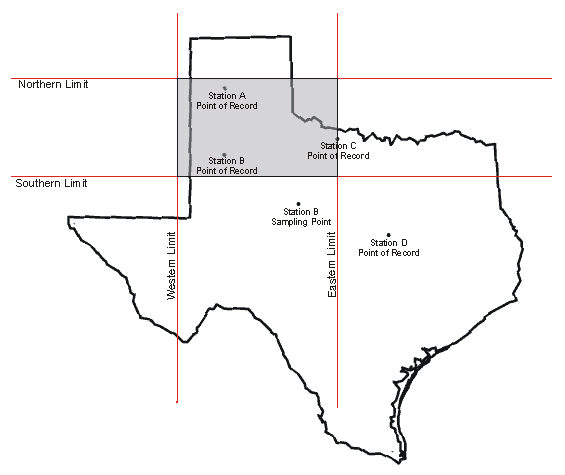
In the example, the shaded area represents the geographical area defined
by the four boundary limits. There are four data retrieval scenarios
depicted as follows:
-
The Point of Record for Station A is entirely within the defined geographic
area. All sampling information associated with Station A will be included
in the report.
-
The Point of Record for Station B is entirely within the defined geographic
area. All sampling information associated with Station B will be included
in the report. This includes the Sampling Point for Station B because
the Point of Record for Station B is within the defined geographic area.
-
The Point of Record for Station C is on the boundary of the defined geographic
area. All sampling information associated with Station C will be
included in the report. If there were Sampling Points for Station
C, they would also be included regardless of their location.
-
The Point of Record for Station D is outside the defined geographic area.
All sampling information associated with Station D will not be included
in the report. If there were Sampling Points for Station D, they
would not be included regardless of their location.
Each boundary limit should be entered as a value in Decimal Degrees.
Position the cursor into the field you want to change and enter the desired
value.
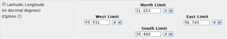
Query by LAT/LONG Bounding Box Northern and Western Hemisphere:
The Equator and the zero longitude line running through Greenwich, England divide the earth into four quadrants.
The United States would be in the Northwest (NW) quadrant, and to reflect this, the latitude values to be entered
for both the North Limit and South Limit will have an "N" placed after them. The North Limit latitude will be always
be larger than the South Limit latitude as it represents a latitude further north of the Equator.
The longitudes in the NW quadrant have a negative sign. However, STORET looks only at the absolute value;
therefore, drop the negative signs when adding longitude values. Both longitudes values to be entered into the
West Limit and East Limit fields will be followed by a "W". The longitude value for the West Limit will always be
larger (in the NW quadrant) than the value for the East Limit, since that longitude is further west of the Greenwich zero longitude.
ie:
-
Example Bounding box in the state of Texas is given below: (in decimal degrees)
Latitude/Longitude diagonal endpoints: (30.448, -99.931) and (31.653, -98.789)
Latitude/Longitude bounding box: 31.653, -99.931 and 30.448, -98.789
Latitude/Longitude bounding box: North Limit, West Limit and South Limit, East Limit
Latitude/Longitude limit direction: N-North, W-West (negative decimal) and N-North, W-West (negative decimal)
Latitude/Longitude bounding box: 31.653 N, 99.931 W and 30.448 N, 98.789 W
-
How to convert decimal degrees into Latitude/Longitude bounding box?
(decimal degrees with "direction: N-North,S-South,W-West,E-East")
-
Decimal Degrees Conversion Algorithm:
Northern Hemisphere: N - North, W - West
Latitude Degree is positive value; North and South Limit direction is "N" - North
Longitude Degree is negative value; West and East Limit direction is "W" - West
-
Southern Hemisphere: S - South, E - East
Latitude Degree is negative value; North and South Limit direction is "S" - South
Longitude Degree is positive value; West and East Limit direction is "E" - East
-
Northern Hemisphere: N - North, W - West
-
North Limit direction "N"
South Limit direction "N"
West Limit direction "W"
East Limit direction "W"
-
North Limit is the Largest positive value (in decimal degrees)
South Limit is the Lowest positive value (in decimal degrees)
West Limit is the Lowest negative value (in decimal degrees)
East Limit is the Highest negative value (in decimal degrees)
-
North Limit: 31.653 NORTH
South Limit: 30.448 NORTH
West Limit: 99.931 WEST
East Limit: 98.789 WEST
Click on image for latitude/longitude point browser
Drainage Basin/HUC Selection
The Drainage Basin/HUC (Hydrologic
Unit Code) Selection allows you to specify the HUC within which you
would like to search for Results or Stations.
To select a HUC, click on the <Look Up> button to bring up
the HUC list in a popup window.
You may select any one HUC from this list by clicking once.
HUC is an optional field in STORET and may be missing for certain Station
Descriptions. Therefore, when searching for data by HUC, it's possible
that not all Stations will be retrieved in the area of interest.
Top Result
Reports Station
Report
Date Range Selection
The Date Range selection area appears in all the Result Selection Criteria
pages. It allows you to select up to four different date ranges.
If the Activity Start Date falls within any of the date ranges then the
result data are selected. The four date ranges have a "from" date
and a "to" date. The "from" date must be less than or equal to the
"to" date. Also, the day must be valid for the specified month.
If you make no adjustments to the defaults, then no record will be filtered
out of the selection process based on Activity Start Date values.
Characteristic Selection
The Characteristic selection area appears in all the Result Selection
Criteria and Station Selection Criteria pages. It allows
you to search and select the Characteristics to use in the Result and Station
searches. It allows you to select Characteristics via Characteristic
Alias Type (e.g., Systematic Name, STORET Parm Code) or the Characteristic
Name itself.
Characteristic Searches
You have been given the option to use Characteristic Aliases or
Characteristic Name to select Characteristics. Select the specific
Characteristic Alias Type (e.g., Systematic Name, STORET Parm Code) or
Characteristic Name, for which you wish to search. Enter as
many characters of the selected Characteristic Alias or Characteristic
Name as you desire for the search string. Click on the <Search>
button, and a popup window will display with the complete list of Characteristics
based on the Characteristic Alias Type or name you selected, and based
on the search string you entered. From the list, highlight
the ones that you would like to select and click on the <Select>
button. The popup window will be closed and the determined Characteristics
will appear in the selected Characteristic Name list. Even when you select
a Characteristic Alias Type, like STORET Parm Code, the software will determine
the Characteristics based on the alias selected, and display these Characteristics
in the selected Characteristic Name list.
EPA's Standards (naming convention) for Substances is the Substance Registry System (SRS)
Search using LIKE Conditions
The LIKE conditions specify a search involving pattern matching.
Whereas the equality operator (=) exactly matches one character value to another,
the LIKE conditions match a portion of one character value to another by searching
the first value for the pattern specified by the second.
The LIKE Conditions can be used to match using a "wildcard search".
Wildcard characters (operators) are used to create the search string.
The two operators are the percent sign ('%') and the underscore ('_').
LIKE condition allows you to use wildcards. This allows you to perform pattern matching.
The patterns that you can choose from are:
% allows you to match any string of any length (including zero length)
_ allows you to match on a single character
Percent Matching
The percent ('%') matches any group of characters.
It can 'stand in' for zero or more characters, with no upper limit.
Consider the string 'wood%' used as search term with LIKE.
Because of the percent sign at the end of the term, the search term will match anything and everything after 'wood'.
It will match on 'wood', 'wooded', 'woodland', 'woods', 'woods!', 'woods in the country' and so on.
It would not match on 'darkwood', 'redwood', or 'parkwoods' because the string starts with 'wood'.
If the search term was '%wood' then it could (and would) attempt to match anything before 'wood'.
It would match on 'darkwood' and 'redwood', 'parkwoods' (default search: match ANY text with the word 'wood' in it).
The term '%wood%' used as search term would match ANY text with the word 'wood' in it. (matches anything before and/or after the text 'wood')
Note: ALL searches have a trailing percent signs which basically matches anything after the text: SEARCH STRING
(ie '%wood' means matches anything before the text ), therefore a match as long as it found 'wood' somewhere in the search text.
Note: ALL searches have a trailing percent signs which basically matches anything after the text: SEARCH STRING
(ie '%wood' means matches anything before the text ), therefore a match as long as it found 'wood' somewhere in the search text.
Note: ALL searches have a trailing percent signs which basically matches anything after the text: SEARCH STRING
(ie '%wood' means matches anything before the text ), therefore a match as long as it found 'wood' somewhere in the search text.
Underscore Matching
The underscore ('_') is more selective- it matches any single character.
Consider the string 'w__d' used as search term with LIKE. The two underscores in the middle tell the LIKE Condition to look for a 'w', then any two characters, and then a 'd'.
This search term will match on 'wood', wild', 'wand', 'ward', and so on. It would not match on 'weird', 'wad', 'wide', or 'wed'. (There are either too few characters or too many to satisfy the match condition.)
Similarly, the search term 'wood_' will match on 'woods', 'woode', 'woody', 'wood!', and any other instance of 'wood' with one and only one additional character after it. It would not match 'wooded', 'woodland', 'redwood', or 'woodsman'.
For example you want to see all characteristics whose name starts with S char.
Then you can use LIKE condition as follows
EXAMPLE: æSÆ or 'S%' <<Search>>
-- æS%Æ like operator in Oracle SQL statement.
You want to see all characteristics whose contains character that starts with æAcetÆ and follows with ædÆ in the string like 'Acetaldehyde', 'Acetaldol', 'Acetamiprid', 'Acetic acid', 'Acetic acid, 2-ethylhexyl ester'.
--You want to see all characteristics whose contain strings of letters that starts with æAcetÆ and ends with ædÆ like 'Acetaldehyde', 'Acetaldol', 'Acetamiprid', 'Acetic acid', 'Acetic acid, 2-ethylhexyl ester'.
EXAMPLE: æAcet%dÆ <<Search>>
--æAcet%d%Æ like operator in Oracle SQL statement.
You want to see those characteristics whose name contains character æacidÆ anywhere in the string.
EXAMPLE: æ%acidÆ <<Search>>
Substance ACRONYMS and Substance ABBREVIATIONS retrieved via <<Search>>
æ%BODÆ <<Search>>,__________æ%(PCP)Æ <<Search>>,__________æ%(NH3)Æ <<Search>>
æ%FUSILADE 2000Æ <<Search>>,__________æ%HALOWAX 1031)Æ <<Search>>,__________æ%MBAAÆ <<Search>>
--æ%acid%Æ like operator in Oracle SQL statement.
To see those characteristics whose name contains æaÆ in second position.
EXAMPLE: æ_aÆ <<Search>>
--æ_a%Æ like operator in Oracle SQL statement.
To see those characteristics whose name contain æ%Æ sign. i.e. æ%Æ sign has to be used as literal not as wild char.
EXAMPLE: æ%!%%Æ <<Search>>
-- æ%!%%Æ escape æ!Æ like operator in Oracle SQL statement.
Note: ALL searches have a trailing percent signs which basically matches anything after the text: SEARCH STRING,
as long as it found the SEARCH STRING somewhere in the search text.
Note: ALL searches have a trailing percent signs which basically matches anything after the text: SEARCH STRING,
as long as it found the SEARCH STRING somewhere in the search text.
Note: ALL searches have a trailing percent signs which basically matches anything after the text: SEARCH STRING,
as long as it found the SEARCH STRING somewhere in the search text.
Taxonomic Names
Because the total number of taxonomic Characteristics is large, the
check box labeled "Hide Taxonomic Names" is checked by default. This
causes the Characteristic search to exclude all taxonomic Characteristics.
If you would like to include taxonomic names in the search, click on the
check box to uncheck it. The list will then display both non-taxonomic
and taxonomic Characteristics. Keep in mind that the only taxonomic
Characteristics that will be returned are ones that have data associated
to them.
Characteristic List Functions
After you have created the selected Characteristic Name list, you still
have the option to remove Characteristics from the list. To remove
all Characteristics from the selected Characteristic Name list, click on
the <Clear All> button. To remove only specific Characteristics
from the list, highlight the Characteristic(s) that you wish to remove,
then click on the <Clear Selected> button.
Selected (AND) Characteristic Search returning SAME Sample(s) with results for "all" selected Characteristics Occuring.
Query returns ONLY sample result records, which includes an occurrence of ALL characteristic on the search list.
Option Functions as a "AND" operator for each selected characteristic displaying a record if "ALL" / both the first condition AND the second condition are true.
Selected (OR) Characteristic Search returning results "if any" selected Characteristics Exists.
Query returns the sample result records, which includes ANY characteristic on the search list.
Option Functions as a "OR" operator for each selected characteristic displaying a record if "ANY" / either the first condition OR the second condition is true.
Sample (AND) Characteristic Search returning whole Sample(s) with "all" selected Characteristics Occurence/Required.
Query returns the entire (whole) sample, which includes ALL characteristic on the search list.
Option Functions as a "AND" operator for each selected characteristic displaying a record if "ALL" / both the first condition AND the second condition are true.
Sample (OR) Characteristic Search returning whole Sample(s) with "if any" selected Characteristics Exists.
Query returns the entire (whole) sample, which includes ANY characteristic on the search list.
Option Functions as a "OR" operator for each selected characteristic displaying a record if "ANY" / either the first condition OR the second condition is true.
Top Result
Reports
Activity Medium Selection
The Activity Medium Selection only appears in the Regular Result Selection
Criteria page. It allows you to search and select records based on
Activity Medium. You can select one or more Activity Mediums
from the list of valid Activity Mediums. The records selected for
the report will contain the results with the selected Activity Mediums
only. If you select the "Select All" option there will be no filter
for Activity Medium.
Activity Intent and Community
Sampled Selection
The Activity Intent and Community Sampled Selections only appear in
the Biological Result Selection Criteria page. There is a list of
Activity Intents from which you can choose one or more. You can also
select one or more Community Sampled from a list; however, Taxon
Abundance is the only Activity Intent with Community Sampled data.
The records selected will be based on the selected Activity Intents or
the combination of the Taxon Abundance Activity Intent and the selected
Community Sampled.
Organization/Station
Selection
The Organization/Station Selection area appears in the Stations by Organization and Station ID and Results by Station
pages. You can narrow the search criteria by selecting an Organization
and one or more Stations within the selected Organization. First,
you select an Organization from the drop down list of Organizations.
After that, you select what attribute you would like to use to search for
a Station list. You can select Station ID, Station Name, or Station
Alias. If you select Station ID or Station Name you can enter as
many characters of a Station ID or Station Name as you desire for the Station
search string and click on the <Search Stations> button. A popup
window with the complete list of Station IDs and Station Names matching
the search criteria will be displayed within the popup window. If
you select Station Alias, click on the <Look Up> button.
A popup window will be displayed with a list of Station Alias Types for
the selected Organization. Highlight your selection and click on
the <Select> button. You can only select a single Station Alias
Type from the list. This will return you to the Selection Criteria
page. Now, you can enter as many characters of the Station
Alias as you desire for the Station search string and click on the <Search
Stations> button. A popup window with the complete list of Station
IDs, Station Alias Types, Station Aliases, and Station Names matching the
search criteria will be displayed within the popup window. The Organization
ID is also displayed in this popup. From the list, highlight the
stations you would like to select and click on the <Select> button.
The popup window will be closed and the selected Station IDs and Station
Names will appear in the selected Stations list.
After you have created the selected Stations list, you still have the
option to remove Stations from the list. To remove all Stations from
the selected Stations list, click on the <Clear All> button.
To remove only specific Stations from the list, highlight the Station(s)
that you wish to remove, then click on the <Clear Selected> button.
To add Stations from another Organization, select another Organization
from the Organization list and follow the steps above to select Stations.
If you leave the defaults intact, there will be no filter for
Organization and Station criteria. If you select an Organization
but do not select any corresponding Stations, then only data for the selected
Organization will be returned. If you select one or more Stations then only records from
the selected Stations will be chosen for the report.
Top Result
Reports
Organization/Project
Selection
The Organization/Project Selection area appears in the Results by Project
page. You can narrow the search criteria by selecting an Organization
and a Project within the selected Organization. First, you select
an Organization from the drop down list of Organizations. After that,
click on the <Look Up> button and a popup window with the complete
list of Project IDs and Project Names within the selected Organization
will be displayed within the popup window. From the list,
highlight the Project that you would like to select and click on the
<Select>
button. The popup window will be closed and the selected Project
Name will appear in the selected Project area.
After you have selected a Project, you can still remove the Project
by selecting an Organization from the "Select an Organization" drop down list.
This will clear your Project selection.
If you leave the defaults intact there will be no filter for Organization
or Project criteria. If you select an Organization but do not select
any corresponding Project, then only data for the selected Organization
will be returned. If you select an Organization and a Project then only the Result records
from the selected Organization/Project will be chosen for the report.
Station Type Selection
The Station Type selection area appears in the Stations by Geographic
Location and Stations by Organization and Station ID pages. It allows you to choose one or more Primary Type/Secondary
Type combinations to use in your Station search. If "Select All"
is chosen, then the Station search would include Stations of any Station
Type.
You may select any one Station Primary Type/Secondary Type from the
Station Type list by highlighting the desired row.
You may hold the <Ctrl> key down as you click additional rows
if you wish to select more than one.
You may hold the <Shift> key down as you click to select all
the rows between the current row and the most recently selected row.
Organization Selection
The Organization selection area appears in the Stations by Geographic
Location page. It allows you to choose one or more Organizations
to use in your Station search. If <Select All> is chosen,
then the Station search would include Stations from any Organization.
You may select any one Organization from the Organization list by highlighting
the desired row.
You may hold the <Ctrl> key down as you click additional rows
if you wish to select more than one.
You may hold the <Shift> key down as you click to select all
the rows between the current row and the most recently selected row.
Pressing the first character of an Organization's code will transfer
the focus to that area of the Organization list.
Top Station
Report
Summary Pages
The Summary Pages for the Result and Station requests are very similar.
They both display the selection criteria of the request and the number
of records selected. Both have a selectable list of data elements
that can be included in reports.
Station
Search Summary Page
This page displays the total count of Stations returned followed by
a list of the Station search parameters entered. If the count of
Station records is zero or more than maximum allowed then you are requested to modify
your search criteria by making it more specific to eliminate records or
more general to allow more records. If the count of Stations falls
between the allowable limits, then a list of Data Elements are displayed.
You can select from this list of Data Elements to customize the content
of your report and continue, or return to the Station Selection Criteria
page. The allowable limits are divided into Online and Batch ranges.
The Batch range includes Immediate and Overnight processing. Immediate option
is only available for lower end of the Batch range. These limits are maintained
by the STORET administrator. This page contains the following sections:
Number of Stations Returned
The number of Stations retrieved with the search criteria you entered
on the previous page.
Search Parameter Values
Summary
This box displays the Station search parameters you entered on the
previous page.
Navigation Options
for Stations
Click on the <Back> button to return to the Station Selection
Criteria page for modifying Station search parameters and refining your
query.
Click on the <Continue> button to generate a report based
on your search criteria and selected data elements.
Choose the <Batch Processing> to submit a request for report based
on your search criteria and selected data elements.
Batch Processing
Provide user profile to categorize the user type. This is
required only for Batch Processing.
Provide email address to report the completion of your request. This is
required only for Batch Processing.
Provide three character string to prefix the data filename. This is required
only for Batch Processing.
Click on the <Immediate> button to submit the request to generate the
report immediately. An email will be sent after completing the process.
Click on the <Overnight> button to submit the request to generate the
report overnight. An email will be sent after completing the process.
Report Customization
for Stations (Select Data Elements for Reports)
If the number of Station records selected are more than zero, then a
list of Data Elements are displayed for you to select for your report.
You may select Data Elements that are appropriate to your Station search
for customizing the content of your report. There are default data
elements selected for you when the page is displayed which are considered
the most notable. You can tailor the content of your report by selecting or
unselecting data elements, via their check box, until you have selected your desired
content. Click on the
<Select
All> button to select all Data Elements, <Clear All> button
to clear all selections, or <Restore Defaults> button to set
the selections back to the default report elements. Some of the displayed
Data Elements are actually Group Elements. These Group Elements represent
more than one Data Element and, if selected, the report will contain the
Data Elements of the group. Once you have selected the data
elements you want to see in the report, then click on the <Continue>
button.
DISTINCT Clause
By Definition:
The DISTINCT clause acts as a filter to remove duplicate records from a result set. It ensures that any records that are returned are unique for the column or columns specified in the SELECT statement. A duplicate row is defined as a row with matching values for each expression in the SELECT list. The DISTINCT keyword is synonymous with the UNIQUE keyword, which is non-standard SQL.
Report Customization for Summary (Using the DISTINCT Clause):
Examples:
Who? has data (monitoring)
ORG_ID, ORG_NAME
What? type of data
CHAR_NAME, MEDIUM, ANALYTICAL METHOD
ACTIVITY TYPES
When? sample/submission event
ACTIVITY_START_DATE
ORG_ID, LAST_CHANGE_DATE
Where? site / geo /site type
ORG_ID, STATION_ID, CHAR_NAME (storetw.station_char)
HUC
COUNTY
STATION_TYPE
Why? Purpose
PROJECT_ID, PROJECT_NAME
NOTE: A Report of Warehouse Domain Values (partial/subset) for a specific query result dataset
More....
Top
Station Group Elements
As mentioned before, there are several Group Elements displayed in
the Station Report's customization screen. A Group Element represents
several data elements. When one selects a Group Element, the data
elements represented by the Group Element will appear in the report.
The following is a list of Group Elements available in the Station Report
and the data elements that are related. The data elements are linked
to the Glossary definitions.
Data Elements for Spring
Info
#13: Spring Type Improvement
#14: Permanence
#15: USGS Geologic
Unit Code-Name
#16: Spring Other Name
#17: USGS Lithologic
Unit Code-Name
Data Elements for
Latitude/Longitude
#21: Latitude
#22: Longitude
#23: Horizontal Datum
Data Elements for
Converted Latitude/Longitude
#24: Converted Latitude
#25: Converted Longitude
#26: Converted Horizontal Datum
Data Elements for Lat/Long
Info
#27: Geopositioning
Method
#28: Map Scale
Data Elements
for Elevation (w/ Units)
#29: Elevation
#30: Elevation Unit
Data Elements
for Additional Elevation Info
#31: Elevation Datum
#32: Elevation Method
Data Elements for RF1 Info
#40: RF1 Segment Code
#41: RF1 Segment Name
#42: RF1 Mileage
#43: On Reach Ind
Data Elements for Estuary
Info
#45: Primary Estuary
#46: Secondary Estuary
#47: Other Estuary
Data Elements for Well Hole Depth Measure
#56: Well Hole Depth Measure
#57: Well Hole Depth Measure Unit
Data Elements for Station Document/Graphic
#58: Station Document/Graphic Name
#59: Station Document/Graphic URL
Data Elements for Administrative Submission/Change Record
#62 Stations / #232 Results: Last Change Date
#63 Stations / #233 Results: Last Transaction ID
#64 Stations / #234 Results: Last User ID
Station Data Elements
The following are the Data Elements available for selection for the
Station Report. The data elements that are italicized are group elements.
Group Elements represent a group of related data elements. When one
selects a Group Element, one will get the related data elements in the
report. The Group Elements are linked to the list of related elements.
The default data elements are in bold and the data elements are linked
to the Glossary to provide the definition.
Top
Result
Search Summary Page
This page is used by each of the Result pages (i.e. Regular, Biological, Habitat, Metric, and Index Results
). This page displays the total count of Results returned
followed by a list of the Result search parameters entered. If the
count of Result records is zero or more than 30,000, then you are requested
to modify your search criteria by making it more specific to eliminate
records, or more general to allow more records. If the count of Results
falls between the allowable limits, then a list of Data Elements is displayed.
You may select the Data Elements to customize the content of
your report and continue, or return to the Result Selection Criteria page.
The allowable limits are divided into Online and Batch ranges. The Batch range
includes Immediate and Overnight processing. Immediate option is only available
for lower end of the Batch range. These limits are maintained by the STORET
administrator. This page contains the following sections:
Number of Results Returned
The number of Results retrieved with the search criteria you entered
on the previous page.
Search Criteria for Results
This box displays the Result search parameters you entered on the previous
page.
Navigation Options for
Results
Click on the <Back> button to return to the Results Selection
Criteria page for modifying result search parameters and refining your
query.
Click on the <Continue> button to generate a report based
on your search criteria and selected data elements.
Choose the <Batch Processing> to submit a request for report based
on your search criteria and selected data elements.
Batch Processing
Provide email address to report the completion of your request. This is
required only for Batch Processing.
Provide three character string to prefix the data filename. This is required
only for Batch Processing.
Click on the <Immediate> button to submit the request to generate the
report immediately. An email will be sent after completing the process.
Click on the <Overnight> button to submit the request to generate the
report overnight. An email will be sent after completing the process.
Report Customization
for Results (Select Data Elements for Reports)
You may select Data Elements that are appropriate to your result search
for customizing the content of your report. The list of Data Elements
available to select differs slightly among Regular Result, Biological Result,
and Habitat Result. There are default data elements selected for
you when the page is displayed which are considered the most notable.
You can tailor the content of your report by selecting or unselecting data
elements, via their check box, until you have selected your desired
content. Click on the
<Select All>
button to select all Data Elements, <Clear All> button to clear
all selections, or <Restore Defaults> button to set the selections
back to the default report elements. Some of the displayed Data Elements
are actually Group Elements. These Group Elements represent more
than one Data Element and, if selected, the report will contain the Data
Elements of the group. Once you have selected the data elements you
want to see in the report, then click on the <Continue> button.
Top
Result Group Elements
As mentioned before, there are several Group Elements displayed in
each of the Result Search Summary pages. A Group Element represents
a group of data elements. When one selects a Group Element, the data
elements represented by the Group Element will appear in the report.
The following is a list of Group Elements and the data elements that are
related. The data elements are linked to the Glossary
to provide definitions.
Data Elements
for Station Location Info
#6: State
#7: County
#8: HUC
#9: Generated HUC
Data Elements
for Station Lat/Long
#10: Station Latitude
#11: Station Longitude
#12: Station Horizontal Datum
Data Elements
for Conv Station Lat/Long
#13: Converted Station Latitude
#14: Converted Station Longitude
#15: Converted Station Horizontal Datum
Data Elements
for Station Types
#16: Primary Type
#17: Secondary Type
Data Elements
for Visit Start
#20: Visit Start
#21: Visit Start Time
Zone
Data Elements
for Visit Stop
#22: Visit Stop
#23: Visit Stop Time
Zone
Data
Elements for Activity Start
#27: Activity Start
#28: Activity Start
Time Zone
Data
Elements for Activity Stop
#29: Activity Stop
#30: Activity Stop
Time Zone
Data Elements
for Actual Activity Lat/Long
#43: Actual Activity Latitude
#44: Actual ActivityLongitude
#45: Actual Activity Horizontal Datum
#46: Actual Activity Horizontal Accuracy
Data Elements
for Conv Actual Activity Lat/Long
#47: Converted Actual Activity Latitude
#48: Converted Actual Activity Longitude
#49: Converted Actual Activity Horizontal Datum
Data Elements
for Additional Act Location Info
#53: Geopositioning
Method
#54: Map Scale
Data Elements for
Sample
Preservation
#65: Container Description
#66: Temp Pres Type
#67: Pres Storage Proc
#68: Transport Storage Desc
Data Elements for
Characteristic Name
#71: Characteristic Name
#72: Characteristic Description
Data Elements for
Result Value as Text
#79: Result Value as Text
#80: Result Value Status
Data Elements for
Activity/Result Comment
#85: Activity Comment
#86: Result Comment
Data Elements
for Additional Anal Proc Info
#96: Detection/Threshold Limit
#97: Detection/Threshold Limit Unit
#98: Detection/Threshold Limit
Descript
#99: Lower Quantification
Limit
#100: Upper Quantification
Limit
#101: All Result Detections/Thresholds
Data Elements for Other
Lab Info
#106: Lab ID
#107: Lab Name
#108: Lab Cert
#109: Lab Batch ID
#110: Analysis Date
#111: Analysis Date
Time Zone
#112: Analysis End Date
Time
#113: Analysis End Date
Time Zone
Data Elements for
Data Quality
#115: Precision
#116: Bias
#117: Confidence Level
#118: Confidence Interval
Data Elements for
Activity/Result Document/Graphic
#120: Result Document/Graphic Name
#121: Result Document/Graphic URL
#122: Activity Document/Graphic Name
#123: Activity Document/Graphic URL
Data Elements for Net
Tow Info
#124: Trawl Start Point
Name
#125: Trawl Start Latitude
#126: Trawl Start Longitude
#127: Trawl Start Horizontal Datum
#128: Conv Trawl Start Latitude
#129: Conv Trawl Start Longitude
#130: Conv Trawl Start Datum
#131: Trawl Start Depth (w/units)
#132: Trawl Stop Point
Name
#133: Trawl Stop Latitude
#134: Trawl Stop Longitude
#135: Trawl Stop Horizontal Datum
#136: Conv Trawl Stop Latitude
#137: Conv Trawl Stop Longitude
#138: Conv Trawl Stop Datum
#139: Trawl Stop Depth (w/units)
#140: Fished Duration
Measure (w/units)
#141: Boat Speed (w/units)
#142: Fished Distance (w/units)
#143: Trawl Rel Current Dir
#144: Trawl Rel Wind Dir
#145: Trawl Comment
#146: Net Information
#147: Net Surface Area
#148: Net Mesh Size
#149: Current Speed
Data Elements for
Electroshock
Info
#150: Voltage Measure
#151: Current Type Code
#152: Amperage Measure
#153: Pass Count
#154: Pass Length Measure
(w/units)
#155: Pulse Rate Measure
#156: Electroshock Comment
#157: Total Energzed Time
(w/units)
Data Elements for
Net
Non-Tow Info
#158: Sampling Duration (w/units)
#159: Orientation to
Current
#160: Trap/Net Rel Current Dir
Dir
#161: Trap/Net Rel Wind Dir
#162: Trap Net Comment
#163: Trap Net Current Speed
#164: Trap Net Mesh Size
#165: Trap Net Surface Area
Data Elements for
General
Group Info
#166: Bio Result Group
ID
#167: Bio Result Group
Type
#168: Bio Result
Group Subject Taxon (w/species #)
#169: Bio Result Group
Desc
Data Elements
for Multi-Taxon Pop Census Info
#170: Feeding Group
#171: Pollution Tolerance Scale
#172: Pollution Tolerance
#173: Trophic Level
#174: Habit
#175: Voltinism
#176: Cell Shape
#177: Cell Form
Data
Elements for Single Taxon Frequency Class Info
#179: Phys/Bio Ind
#180: Bio Result
Group ID (sex)
#181: Bio Result
Group ID (lifestage)
#182: Bio Result
Group Class Var
#183: Class Prim Desc
#184: Class Sec Desc
#185: Class Lower Bound
#186: Class Upper Bound
#187: Class Units
Data Elements
for Single Taxon Individual Info
#188: Number in Group
#189: Bio Individual
Number
Data Elements
for Collection Duration Info
#190: Sampling Component
#191: Place In Series
Data Elements
for Reach Measure
#192: Reach Length
#193: Reach Width
Data Elements
for Toxicity Test Type
#194: Toxicity Test Type
Data Elements
for Result Depth Height
#195: Result Depth Height
#196: Result Depth Height Unit
#197: Result Depth Altitude Ref Point
#198: Result Sampling Point
Data Elements
for Bio Individual
#199: Bio Individual
Data Elements
for Unidentified Species ID
#200: Species ID
Data Elements
for Group Summary Count Weight
#201: Group Summary Count Weight
Data Elements
for Frequency Class
#202: Frequency Class
Data Elements
for Laboratory Accreditation Indicator
#203: Taxa Accred Authority
#204: Lab Accred Authority
#205: Taxa Accred YN
Data Elements
for Lab Sample Preparation ID
#206: Lab Sample Preparation ID
Data Elements
for Lab Sample Prep Info
#207: Sample Prep Start Date
#208: Sample Prep Start Date Zone
#209: Sample Prep End Date
#210: Sample Prep End Date Zone
Data Elements
for Dilution Factor
#211: Dilution Factor
Data Elements
for Activity Conducting Organization
#212: Activity Conducting Organization
Data Elements
for Metric Type ID
#213: Metric Type ID
Data Elements
for Metric Value
#214: Metric Value
Data Elements
for Taxon Detail Citation ID
#215: Taxon Detail Citation ID
Data Elements
for Metric Context
#216: Metric Context
Data Elements
for Metric Unit
#217: Metric Unit
Data Elements
for Metric Score
#218: Metric Score
Data Elements
for Metric Name
#219: Metric Name
Data Elements
for Metric Scale
#220: Metric Scale
Data Elements
for Metric Comment
#221: Metric Comment
Data Elements
for Formula Description
#222: Formula Description
Data Elements
for Metric Detail Citation ID
#223: Metric Detail Citation ID
Data Elements
for Index ID
#224: Index ID
Data Elements
for Index Type ID
#225: Index Type ID
Data Elements
for Index Type Name
#226: Index Type Name
Data Elements
for Index Type Citation
#227: Index Type Citation
Data Elements
for Index Type Scale Text
#228: Index Type Scale Text
Data Elements
for Index Score
#229: Index Score
Data Elements
for Index Qualifier Code
#230: Index Qualifier Code
Data Elements
for Index Comment
#231: Index Comment
Data Elements
for Index Calculated Date
#232: Index Calculated Date
Data Elements
for Index Activity ID
#233: Index Activity ID
Data Elements for Administrative Submission/Change Record
#233: Last Change Date
#234: Last Transaction ID
#235: Last User ID
Top
Regular Result Data Elements
The following are the Data Elements available for selection for the
Regular Results Report. The data elements that are italicized are
group elements. Group elements represent a group of related data
elements.
When one selects a Group Element, one will get the related data elements
in the report. The Group Elements are linked to the list of related elements.
The default data elements are in bold, and the data elements are linked
to the Glossary to provide the definition.
Biological Result Data
Elements
The following are the Data Elements available for selection for the
Biological Results Report. The data elements that are italicized
are group elements. Group elements represent a group of related data
elements. When one selects a Group Element, one will get the related
data elements in the report. The Group Elements italicized below
are linked to the list of related elements. The default data elements
are in bold, and the data elements are linked to the Glossary
to provide the definition.
Habitat Result Data Elements
The following are the Data Elements available for selection for the
Habitat Results Report. The data elements that are italicized are
group elements. Group elements represent a group of related data
elements. When one selects a Group Element, one will get the related
data elements in the report. The Group Elements italicized below
are linked to the list of related elements. The default data elements
are in bold, and the data elements are linked to the Glossary
to provide the definition.
Metric Result Data
Elements
The following are the Data Elements available for selection for the
Metric Results Report. The data elements that are italicized
are group elements. Group elements represent a group of related data
elements. When one selects a Group Element, one will get the related
data elements in the report. The Group Elements italicized below
are linked to the list of related elements. The default data elements
are in bold, and the data elements are linked to the Glossary
to provide the definition.
Index Result Data
Elements
The following are the Data Elements available for selection for the
Index Results Report. The data elements that are italicized
are group elements. Group elements represent a group of related data
elements. When one selects a Group Element, one will get the related
data elements in the report. The Group Elements italicized below
are linked to the list of related elements. The default data elements
are in bold, and the data elements are linked to the Glossary
to provide the definition.
Top
Watershed
Summary
Watershed summary report provides a summary of STORET results for a chosen Hydrologic Unit Code,
grouped by organization or characteristic type. A dropdown list of Hydrologic Unit Codes is displayed,
from which you can choose a Hydrologic Unit Code and request for summary information.
The Search By radio buttons provided on the web page allow you to choose one out of the two formats for watershed summary display.
Get Organization Summary and Download Results for One or All organization(s)
This page displays the number of organizations, stations, characteristics and results for the selected watershed.
Name of each organization within the selected watershed is displayed with a radio button. Number of stations, and distibution of
results across the various characteristic types for each organization will be displayed as hyperlinks.
The stations hyperlink lists station names and number of results of each station, for the selected organization within the watershed.
The hyperlinks attached to the characteristic types provide names and number of results for each characteristic of the selected characteristic
type found within the selected organization and watershed.
Get Characteristic Type Summary and Download Results for Selected Characteristic Type(s)
This page displays the total number of characteristics and the total number of results available for the selected watershed.
Names of characteristic types found across the results of the watershed are displayed.
The check boxes displayed next to each of the characteristic type allow you to choose one or more of the characteristic types, and request STORET result data for the watershed for the selected characteristic types.
Top
Download
Results Page
Download
Results Page General
This page gives you the option to download your report or to have it
compressed first before downloading. It displays the size of your report
in kilobytes to assist you in deciding to compress (zip) the report or not.
Click on the link "Download your file now..." to download your report.
Click the "Compress Data File Now" button to proceed with compressing your report. Another
download page is brought up when you select to compress your
report. From this page you can download your compressed report.
Explanation of
Result Report Format
The generated report provides the available information associated with the selected data
elements when Results exist that match the search criteria.
The file will be "Tilde Delimited" flat ASCII text. The Tilde character
(i.e., ~) is found on many keyboards at the top left, just above the TAB
key, and looks like a horizontal "S".
This unusual character has been used as a delimiter because of its lower
likelihood of appearing in any of your downloaded data over other more
common characters.
Download
Site Descriptions Page
Download Site
Descriptions Page General
This page gives you the option to download your report or to have it
compressed first before downloading. It displays the size of your report
in kilobytes to assist you in deciding to compress (zip) the report or not.
Click on the link "Download your file now..." to download your report.
Click the "Compress Data File Now" button to proceed with compressing your report. Another
download page is brought up when you select to compress your
report. From this page you can download your compressed report.
Explanation of
Station Report Format
The generated report provides the available information associated with the selected data
elements when monitoring sites exist that match the search criteria.
The file will be "Tilde Delimited" flat ASCII text. The Tilde character
(i.e., ~) is found on many keyboards at the top left, just above the TAB
key, and looks like a horizontal "S".
This unusual character has been used as a delimiter because of its lower
likelihood of appearing in any of your downloaded data over other more
common characters.
Download
Your Compressed Data File
If you select to compress your report, a download page is opened. This page
allows you to download your compressed report. The file size is given to help you
decide whether to download or not. The report is
compressed using a UNIX tool. The compressed file has an extension
of ".gz". This stands for GZIP. Most compression or Zip software recognizes this extension and is compatible
with the file. However, some Zip software will not be able to unzip
this file. By clicking on the link "Download your compressed file
now..." your default Zip software will open ready to unzip your report.
Depending on your browser's settings, you may
be prompted to either open or save your compressed file before your Zip software
is called. You can save it to a directory of your choice or unzip
the report right away. The report is the same tilde delimited file
described in the Download Results Page and the Download Site Descriptions
Page. It should be noted that the Netscape browser does not work
properly with the zip enhancement. It unzips the file immediately,
instead of bringing up the zip program to allow you to determine what to do with the file.
Retrieving Documents/Graphics
Retrieving documents/graphics requires a few additional steps when
customizing and downloading your Station or Result report.Ā When
customizing your report the data elements associated with Station
documents/graphics are Station Document/Graphic Name
and Station Document/Graphic URL.Ā These data elements can be selected from the Station Search Summary page.Ā The data elements associated with Result
documents/graphics are Result Document/Graphic Name
and Result Document/Graphic URL.Ā The data elements associated with Activity documents/graphics are Activity Document/Graphic Name
and Activity Document/Graphic URL.Ā Documents/graphics for both Activity and Result data can be selected from the Result Search Summary page.Ā For each
type of documents/graphics (Station, Result, or Activity) the
Document/Graphic Name data element provides the title or name ofĀ the
documents/graphics.Ā The Document/Graphic URL data element provides the
address or Uniform Resource Locator (URL) of the web page that can
download your documents/graphics.Ā This data element is essential to
retrieve your documents/graphics.Ā The Document/Graphic Name data
element is optional.
To retrieve a documents/graphics, select, at least, the
Document/Graphic URL data element for which you are interested.
Download your report as usual.Ā Highlight the URL that appears in the
body of the report.Ā Copy and paste it into the "Address" prompt on
your web browser and hit "Enter".Ā Make sure the complete URL is copy
and pasted.Ā This will open the Download Document/Graphic page.
Clicking on the "Download your Document/Graphic now..." link will open
the documents/graphics on your browser or with other software
compatible with the file type.
The URL contained in your Document/Graphic URL data element will remain
accurate and can be used again without running another report, unless
that documents/graphics record gets modified through STORET's data
entry.
Download Document/Graphic Page
As mentioned above, this page is displayed when the value in the
Document/Graphic URL data element is transcribed to the address prompt
of your web browser.Ā By clicking on the linkĀ "Download your
Document/Graphic now..."Ā the document or graphic being pointed to by
the URL is downloaded and opened on your browser or with other software
compatible with the file type.
Top
Glossary
Activity Category
A descriptor used to distinguish different kinds of samples and different
kinds of Measurements & Observations.
Activity Category-Rep Num
This is the concatenation of Activity
Category and Replicate Number.
An Activity Category is a descriptor used to distinguish different kinds
of samples and different kinds of Measurements & Observations.
A Replicate Number is a user-assigned number applied to samples/measurements
of the same type, medium, etc. to differentiate between them (e.g., Water
Replicate 1 and Water Replicate 2). Note: This applies
only to certain Activity Categories for Samples (replicate, field replicate,
depletion replicate, sample created from sample) and Measurements (measurement
replicate)- not Observations.
Activity Depth
Distance from the surface to the point in the water column at which
the activity is conducted.
Activity Depth Unit
The code that represents the units in which the depth to activity is
expressed.
Activity Document/Graphic
Name
An activity may be further described by a document or graphic. This
field defines the title of the documents/graphics which further defines
this activity.
Activity Document/Graphic
URL
A Uniform Resource Locator (URL) is an address of a file accessible on
the internet. In this case, it is the address of a Document/Graphic
describing an activity.
Activity ID
The Organization-assigned alphanumeric code that identifies a Field
Activity, sometimes called Sample ID. The combination of Activity/Sample
ID and Replicate Number must be unique among all samples collected during
one Station visit conducted during any one Trip.
Activity Intent
The primary reason the Field Activity occurred. Note: This
is mandatory for Biological Medium, and not available for other media.
Activity Comment
Free text comments usually originating from members of the field crew regarding the Field
Activity.
Activity Lower Depth
This measure is associated with an activity that is normally conducted
over or within a vertical depth range within the water column. This
attribute is a measure of the distance from the surface to the lower boundary
of the zone within which the activity is conducted or over which the activity
is integrated.
Activity Matrix
The short name of the Sample Matrix.
Activity Medium
The name of the medium where the Field Activity occurred.
Activity Rel Depth
The name that indicates the approximate location within the water column
at which the activity occurred.
Activity Start
For Samples Collected or for Measurements/Observations made - the date
and time that the Field Activity began. For Samples Created from
other samples - the date and time on which a sample is created by compositing,
splitting, or subsampling from a parent sample. It is a date/time
attribute containing Activity Start Date and Activity Start Time.
Activity Start Time Zone
Time Zone for Activity Start.
Activity Stop
Date and time that the Field Activity ended. It is a date/time
attribute containing Activity Stop Date and Activity Stop Time.
Activity Stop Time Zone
Time Zone for Activity Stop.
Activity Type
The type of the Field Activity being performed, used to distinguish
between field samples and field measurements and observations.
Activity Upper Depth
This measure is associated with an activity that is normally conducted
over or within a vertical depth range within the water column. This
attribute is a measure of the distance from the surface to the upper boundary
of the zone within which the activity is conducted or over which the activity
is integrated.
Actual Activity Latitude
The Latitude (in decimal degrees) for the absolute location point of
the Activity. Latitudes South of the Equator are negative.
Actual Activity Longitude
The Longitude (in decimal degrees) for the absolute location point
of the Activity. Longitudes in the Western Hemisphere (including
the entire continental United States) are negative.
Top
Actual Point Type
The code that identifies the type of location for an Absolute Location
Point.
Actual Point Name
User-specified free text name by which a specific absolute location
point will be known.
Actual Point Sequence
The number that indicates the sequence position of current point among
a group of points. For example, if several points are recorded to
mark the boundary of a Station, the sequence number specifies the order
in which the system should "connect the dots."
Amperage Measure
The rate of current flow (amperes) produced by the electroshock
equipment used to collect the Sample.
Analysis Date
The date on which laboratory analysis of the sample for this particular
result was performed.
Analysis Date Time Zone
The time zone of the Analysis Date.
Analytical Proc Name
The full title of the analytical procedure.
Analytical Proc ID
A combination of an abbreviation or acronym identifying the Organization
that owns the analytical procedure (e.g. ASTM, USGS, and EPA) and the abbreviated
name or identifying code of the analytical procedure.
Activity
This allows for the reporting of monitoring activities conducted at a Monitoring Location
Activity Group
Allows for the grouping of activities
ActivityAttachedBinaryObject
This allows for the association of References and electronic attachments to the Activity description including any other documents, images, maps, photos, laboratory materials, geospatial coverages, and other objects associated with the Project..
ActivityBottomDepthHeightMeasure
A measurement of the lower vertical location of a vertical location range (measured from a reference point) at which an activity occurred.
ActivityCommentText
General comments concerning the activity.
ActivityConductingOrganizationText
A name of the Organization conducting an activity.
ActivityDepthAltitudeReferencePointText
The reference used to indicate the datum or reference used to establish the depth/altitude of an activity.
ActivityDepthHeightMeasure
A measurement of the vertical location (measured from a reference point) at which an activity occurred.
ActivityEndDate
The calendar date when the field activity was completed.
ActivityEndTime
The measure of clock time when the field activity ended.
ActivityGroupIdentifier
Designator that uniquely identifies a grouping of activities within an organization.
ActivityGroupName
A name of an activity group.
ActivityGroupTypeCode
Identifies the type of grouping of a set of activities
ActivityIdentifier
Designator that uniquely identifies an activity within an organization.
ActivityLocation
This allows for the geospatial description of actual monitoring site, if it is different from that described for in the formal station description.
ActivityMediaName
Name or code indicating the environmental medium where the sample was taken.
ActivityMediaSubDivisionName
Name or code indicating the environmental matrix as a subdivision of the sample media.
ActivityMetric
This allows for the reporting of metrics to support habitat or biotic integrity indices.
ActivityMetricType
This identifies the metric type reported as part of an activity metric.
ActivityRelativeDepthName
The name that indicates the approximate location within the water column at which the activity occurred.
ActivityStartDate
The calendar date on which the field activity was started.
ActivityStartTime
The measure of clock time when the field activity began.
ActivityTopDepthHeightMeasure
A measurement of the upper vertical location of a vertical location range (measured from a reference point) at which an activity occurred.
ActivityTypeCode
The text describing the type of activity.
AddressText
The address that describes the physical (geographic), shipping, or mailing location of an organization.
AddressTypeName
Categorizes an address as either location, shipping, or mailing address.
AlternateMonitoringLocationIdentity
Alternate identifications of a monitoring location.
AnalysisEndDate
The calendar date on which the analysis was finished.
AnalysisEndTime
The local time and relative time zone when the analysis was finished.
AnalysisStartDate
The calendar date on which the analysis began.
AnalysisStartTime
The local time and relative time zone when the analysis began.
AquiferName
Name of the aquifer in which the well is completed.
AssemblageSampledName
An association of interacting populations of organisms in a given waterbody.
AttachedBinaryObject
This allows for the association of References and electronic attachments to the Monitoring Location or Result description description including any other documents, images, maps, photos, laboratory materials, geospatial coverages, and other objects associated with the Project.
Top
Bias
A consistent deviation of measured values from the true value, caused
by systematic errors in a procedure, as determined by applying the identical
procedures to a specimen of known properties.
Bio Individual Number
System assigned sequence number to the individual in accordance with
the total number of individuals reported by the user. Once assigned,
this number does not change and cannot be changed/deleted.
Each defined group of individuals gets an increasing series of "individual
numbers" beginning with 1 for the identification of individual specimens from the original
group. Results then describe the specific individual.
Bio Result Group Class Var
The name of the characteristic when the group is Single
Taxon Frequency Classes based on Physical measures.
Bio Result Group Desc
Additional user-specified text describing the biological result group.
Not intended to replace results with characteristics with text values.
Bio Result Group ID
The user-assigned number that identifies a Biological Result Group.
Bio Result Group ID
(lifestage)
The lifestage of all organisms in the biological result group, when
the group is Single Taxon Frequency Classes based on Physical measures.
Bio Result Group ID (sex)
The sex of all organisms in the biological result group, when the group
is Single Taxon Frequency Classes based on Physical measures.
Bio Result Group Subject
Taxon (w/species #)
This field is a combination of two fields. Part of it is a number
that is assigned as a part of a taxonomic identification. Used with
a valid genus (or higher taxonomic rank) to indicate a unique species has
been observed but not taxonomically identified (e.g., Lepomis sp.1).
It is also the name of the taxonomic characteristic.
Bio Result Group Type
The name of the kind of group. Examples include: 1. Multi-Taxon
Population Census 2. Single taxon frequency class
3. Single taxon group summary 4. Single taxon individual
Biopart
The usual anatomical term which identifies the portion of an organism
to be analyzed.
Boat Speed
The relative speed, through the water, of the boat during Sample collection.
This field also includes the code that represents the unit in which the
boat speed is expressed.
CAS Num
Chemical Abstract Service Registry Number. It is a unique identifier
for chemicals.
Cell Form
The name of the cell form for cellular organisms expressed as
a result. A single cellular species may have a result value
for any or all of these cell forms.
Cell Shape
The cell shape of the cellular organism. For example, a
chrysophyta can have a form and a shape.
Characteristic Name
The name of the characteristic as it is to be displayed
on windows and reports.
BiasValue
The systematic or persistent distortion of a measurement process which causes error in one direction.
BinaryObjectFileName
The text describing the descriptive name used to represent the file, including file extension.
BinaryObjectFileTypeCode
The text or acronym describing the binary content type of a file.
BiologicalActivityDescription
This allows for the reporting of biological monitoring activities conducted at a Monitoring Location
BiologicalHabitatCollectionInformation
Allows for the reporting of biological habitat sample collection information
BiologicalHabitatIndex
This allows for the reporting of habitat and biotic integrity indices as a representation of water quality conditions.
BiologicalIndividualIdentifier
A number uniquely identifying the individual in accordance with the total number of individuals reported by the user.
BiologicalIntentName
The primary reason the biological monitoring has occurred.
BiologicalResultDescription
This allows for the reporting of biological result information.
BoatSpeedMeasure
A measurement of the boat speed during biological monitoring sample collection.
Top
Characteristic Group Type
A Characteristic Group Type represents a group of characteristics.
Each Characteristic is assigned to one or more characteristic types.
This list is maintained by USGS NWIS or Water Quality Portal Team.
| WQP Group Name |
WQP Group Description |
| Information |
Information about a data-collection site, sampling activity, analytical procedure, or quality-assurance measurement (Evaluation order 18) |
| Physical |
General quantitative and qualitative observations as well as results computed from field and laboratory observations (Evaluation order 12) |
| Inorganics, Major, Metals |
Major metallic cations (including sodium, calcium, magnesium, and potassium); generally present in concentrations of milligrams per liter. (Evaluation order 4) |
| Inorganics, Major, Non-metals |
Major non-metallic anions (including chloride, fluoride, sulfate, and alkalinity related); generally present in concentrations of milligrams per liter. (Evaluation order 5) |
| Nutrient |
Nitrogen- or phosphorus-based constituents. (Evaluation order 3) |
| Microbiological |
Bacteria, viruses, protozoans, or other microbial constituents. (Evaluation order 14) |
| Biological |
Algal and zooplankton constituents (including productivity, chlorophyll, and biomass). Information about biological samples (for example, sample size and weight parameters), including tissue samples, are grouped as Biological. (Evaluation order 17) |
| Inorganics, Minor, Metals |
Trace metal cations or metal-based compounds; generally present in micrograms per liter. (Evaluation order 6) |
| Inorganics, Minor, Non-metals |
Trace non-metallic elements or non-metallic based compounds, generally present in micrograms per liter. (Evaluation order 7) |
| Organics, Pesticide |
Organic pesticide compounds, including their break-down products. When a chemical compound has more than one use, if the predominant use is for pesticides, it is assigned to this group; if the predominant use is other than as a pesticide, it is assigned to "Organics, other". (Evaluation order 10) |
| Organics, PCBs |
Polychlorinated biphenol compounds, including their break-down products. (Evaluation order 9) |
| Organics, Other |
Organic compounds not classified as pesticides or polychlorinated biphenol compounds, including volatile organic compounds and oil/grease constituents. (Evaluation order 11) |
| Radiochemical |
Radioactive constituents, including gross alpha, gross beta, uranium, and radon. (Evaluation order 2) |
| Stable Isotopes |
Isotopic constituents that are stable and not radioactive in nature, including isotope ratios. (Evaluation order 1) |
| Sediment |
Physical sediment-related constituents, including suspended sediment and bedload sediment. This group does not include parameters for the chemical analysis of sediment or dissolved solids. (Evaluation order 8) |
| Population/Community |
Biological population or community information. (Evaluation order 15) |
| Habitat |
Physical habitat measurements. (Evaluation order 16) |
| Toxicity |
Toxicity-test measurements. (Evaluation order 13) |
| Other |
Other miscellaneous constituents. (Evaluation order 19) |
| Not Assigned |
Compounds not yet classified or pending classification of an expert chemist: email documented and expert recommendations to STORET Helpdesk (storet@epa.gov). |
Characteristic Type
A Characteristic Type represents a group of characteristics.
Each Characteristic is assigned to one or more characteristic types.
This list is maintained by EPA STORET Team.
| STORET Characteristic Type |
STORET Characteristic Type Description |
| Biological |
Biological population or community information as represent by a Taxonomic Hierarchy |
| Habitat |
Physical habitat measurements. |
| Metals |
Major metallic cations (including sodium, calcium, magnesium, and potassium) and Trace metal cations or metal-based compounds. |
| Microbiological |
***retired date 2014-01-24 **** Bacteria, viruses, protozoans, or other microbial constituents (including Algal and zooplankton constituents). |
| Microbiological - Autotrophic |
Microbial constituents ¢ producers such as plants or algae. |
| Microbiological - Contaminants |
Microbial constituents - anything other than the intended organism to grow. |
| Microbiological ¢ Heterotrophic |
Microbial constituents ¢ consumers of (autotrophs) organic matter. |
| Microbiological - Other |
Microbial constituents - Organics, Inorganics and others. |
| Not Assigned |
Compounds not yet classified or pending classification of an expert chemist: email documented and expert recommendations to STORET Helpdesk (storet@epa.gov). |
| Nutrient |
Nitrogen- or phosphorus-based constituents. |
| Other |
Other miscellaneous constituents. |
| PBDEs |
Polybrominated diphenyl ether compounds, including their break-down products. |
| PCBs |
Polychlorinated biphenol compounds, including their break-down products. |
| Pesticide |
Pesticide compounds, including their break-down products. When a chemical compound has more than one use, if the predominant use is for pesticides, it is assigned to this group; if the predominant use is other than as a pesticide, it is assigned to "Other". |
| Physical |
General quantitative and qualitative observations as well as results computed from field and laboratory observations. |
| Radiation |
Radioactive constituents, including gross alpha, gross beta, uranium, and radon. |
Class Lower Bound
Represents the value of the lower bound of the result class interval.
Class Prim Desc
For Single Taxon Frequency Classes based on biological conditions for
a group of organisms, this defines either the Sex or the Lifestage
of all organisms participating in the frequency class.
Class Sec Desc
For Single Taxon Frequency Classes based on biological conditions for
a group of organisms, this optionally defines either the Sex or the Lifestage
(whichever was not used as Primary) of all organisms participating in the
frequency class.
Class Upper Bound
Represents the value of the upper bound of the result class interval.
Community Sampled
The name of the Biological Community from which the Sample was taken.
Note: This is only valid when medium is Biological and the intent type
is Taxon Abundance. It is mandatory for that combination of descriptors.
Confidence Level
A statistical calculation measuring the certainty about the result.
Container Description
The style and material of the container, the color of the container,
the measure of the size of the container, and the unit which the size of
the container is expressed which is used to collect and transport a sample.
Container Color
The description of the color of the container used to collect and transport
the sample.
Converted Actual Activity Latitude
The Latitude (in decimal degrees) for the absolute location point of the Activity. Latitudes South of the Equator are negative. This value has been converted to standard units where possible to assist with data analysis.
Converted Actual Activity Longitude
The Longitude (in decimal degrees) for the absolute location point of the Activity. Longitudes in the Western Hemisphere (including the entire continental United States) are negative. This value has been converted to standard units where possible to assist with data analysis.
Converted Actual Activity Horizontal Datum
The set of reference points from which the Latitude and Longitude were determined. Accuracy of the latitude/longitude determination is affected by the choice of a datum. This value has been converted to standard units where possible to assist with data analysis.
Converted Result Value
The numeric representation of the result value for fully numeric values. Note: This value will be determined by converting the text values from Value Text. This conversion to numeric is always attempted during data entry, and when successful, its result is placed in this field. This value has been converted to standard units where possible to assist with data analysis.
Converted Result Unit
The unit of measure. This value has been converted to standard units where possible to assist with data analysis.
Converted Trawl Start Latitude
The measure of latitude in decimal degrees (-90.0 to 90.0) indicating angular distance North or South of the equator where the trawl began. This value has been converted to standard units where possible to assist with data analysis.
Converted Trawl Start Longitude
The measure of longitude in decimal degrees (-180.0 to 180.0) indicating angular distance west or east of the prime meridian where the trawl began. This value has been converted to standard units where possible to assist with data analysis.
Converted Trawl Start Datum
The set of reference points from which the Latitude and Longitude were determined. Accuracy of the latitude/longitude determination is affected by the choice of a datum. This value has been converted to standard units where possible to assist with data analysis.
Converted Station Latitude
The Latitude (in decimal degrees) at which the Station's Point of Record is located. Latitudes South of the Equator are negative. Every STORET Station has a Point of Record. This value has been converted to standard units where possible to assist with data analysis.
Converted Station Longitude
The Longitude (in decimal degrees) at which the Station's Point of Record is located. Longitudes in the Western Hemisphere (including the entire continental United States) are negative. This value has been converted to standard units where possible to assist with data analysis.
Converted Station Horizontal Datum
The set of reference points from which the Latitude and Longitude were determined. Accuracy of the latitude/longitude determination is affected by the choice of a datum. This value has been converted to standard units where possible to assist with data analysis.
Converted Trawl Stop Latitude
The measure of latitude in decimal degrees (-90.0 to 90.0) indicating angular distance North or South of the equator where the trawl ended. This value has been converted to standard units where possible to assist with data analysis.
Converted Trawl Stop Longitude
The measure of longitude in decimal degrees (-180.0 to 180.0) indicating angular distance west or east of the prime meridian where the trawl ended. This value has been converted to standard units where possible to assist with data analysis.
Converted Trawl Stop Datum
The set of reference points from which the Latitude and Longitude were determined. Accuracy of the latitude/longitude determination is affected by the choice of a datum. This value has been converted to standard units where possible to assist with data analysis.
Correction for Bias Ind
A code indicating whether the confidence level has been corrected for
Bias.
Correction Indicator
A code indicating whether the reported result has been adjusted in
accordance with a correction factor.
Country Code
A 2-character abbreviation that is used to uniquely identify a country.
( i.e., US for the United States and its territories, CN for Canada, and
MX for Mexico.)
Country Name
The country name (English spelling). Only Canada, the United States,
and Mexico are included in STORET.
County
For Stations in the United States (only), the name of the county or
county equivalent in which the Station is located.
Current Type Code
The code that represents the type of current produced by the electroshock
equipment.
CellFormName
The name of the cell form for phytoplankton organisms expressed as a result. A single phytoplankton species may have a result value for any or all of these cell forms.
CellShapeName
The cell shape of the phytoplankton organism.
CharacteristicName
The object, property, or substance which is evaluated or enumerated by either a direct field measurement, a direct field observation, or by laboratory analysis of material collected in the field.
ChemicalPreservativeUsedName
Information describing the chemical means to preserve the sample.
CollectionDuration
The length of time a collection procedure or protocol was performed (e.g. total energized time for electrofishing, or total time kick net used).
CommentText
General comments about the project monitoring location weighting.
ConfidenceIntervalValue
A range of values constructed so that this range has a specified probability of including the true population mean.
CountryCode
A acronym or code designator used to identify a primary geopolitical unit of the world.
CountyCode
A Federal Information Processing Standards (FIPS) County code designator used to identify a U.S. county or county equivalent.
CurrentSpeedMeasure
A measurement of the current during biological monitoring sample collection.
Top
Data Owner
The Entity that can authorize or deny access to certain data, and is responsible for its accuracy,
integrity, and timeliness. A data owner maybe assigned one or more organization ids.
Contact information is contained in the Organization Summary section of each Metadata report.
Description Text
Contains the organization-defined description of the station.
This text could include the distance of the left or right shore to the station, or any other
information that would further identify the station.
Detection/Threshold Limit
Represents the least amount of the target substance which could be
detected by the instrument/analytical process employed to determine the
result. Above this value the target substance is presumed to be present.
Detection/Threshold Limit Unit
Represents the unit of measure.
Detection/Threshold Limit Descript
Text providing further description and comment on the detection and/or
threshold limits, for example "Instrument Detection Level (IDL)", "Method Detection Level (MDL)", etc.
All Result Detections/Thresholds
Represents a delimited list of detection thresholds and limits referenced by the instrument/analytical process employed to determine the result. Each threshold and/or limit is separated by a semicolon (';') as the delimiter.
Dilution Indicator
A code indicating that the result has been calculated from an analysis
performed on a diluted sample.
Distance Measured From
The point from which a measurement such as surface elevation or stream
width is taken.
Distance Measured to
The point to which a measurement such as stream width or surface elevation
was taken.
Duration Basis
The period of time (in days) over which a measurement was made.
Electroshock Comment
User-defined text that provides further information about the Electroshock
Operation.
DataLoggerLineName
The unique line identifier from a data logger result text file, normally a date/time format but could be any user defined name, e.g. surface, midwinter, and or bottom.)
DataQuality
The quantitative statistics and qualitative descriptors that are used to interpret the degree of acceptability or utility of data to the user.
DetectionQuantitationLimitMeasure
Constituent concentration that, when processed through the complete method, produces a signal that is statistically different from a blank.
DetectionQuantitationLimitTypeName
Text describing the type of detection or quantitation limit used in the analysis of a characteristic.
Top
Elevation
The vertical distance above or below sea level at which the Station
is located.
Elevation Unit
Represents the unit of measure.
Elevation Datum
The set of reference points from which elevation measurements were
made. The accuracy of an elevation determination is affected by the
choice of a datum.
Elevation Method
The method by which the elevation measurements were made. The
accuracy of the elevation determination is affected by the choice of a
method.
EPA Registry Num
A number used to standardize the identification of characteristics.
External Reference Scheme Acronym
The abbreviation or acronym of the external reference scheme in which
the Station participates. For example, if the reference is to the
National Pollution Discharge Elimination System the acronym is NPDES.
ElectronicAddress
This allows for the description of many electronic addresses per owning Organization.
ElectronicAddressText
A resource address, usually consisting of the access protocol, the domain name, and optionally, the path to a file or location.
ElectronicAddressTypeName
The name that describes the electronic address type.
Top
Feeding Group
For entries representing taxa, a code representing the functional feeding
group with which the reported taxon is typically associated.
Field Gear Configuration ID
The code that identifies a Gear Configuration within the Organization.
Field Gear ID
An Organization-assigned ID Code that identifies a specific
instance of Field Gear. Note: One Field Gear may have many
Gear Configurations. Used as a shorthand or abbreviation to represent the
Field Gear in batch data update runs.
Field Procedure ID
The short name (i.e., abbreviation or acronym) listed
in reference document.
Field Procedure Name
The name of the sampling procedure, as listed in the reference document.
Field Set
The long name assigned by the Organization to identify and group field
activities.
FIPS County Code
The Federal Information Processing Standard (FIPS) code, a 3-digit
integer, used by government agencies to identify Counties and County equivalents
within the States of the United States. Canadian Provinces and Mexican
States have no counties.
FIPS State Code
The Federal Information Processing Standard (FIPS) code, a 2-digit
integer, used by government agencies to identify States within the countries
of North America.
Fished Distance
The distance over which the trawl was operated for Sample collection.
This field also includes the code that represents the units in which the
fished distance is expressed.
Fished Duration Measure
The length of time the Trawl is considered to be operational (i.e.,
collecting). This field also includes the code that represents the
units in which the fished duration is expressed.
FRS Key Identifier
FRS is the Facility Registry System, a scheme adopted by EPA to uniquely
identify facilities in which EPA has a regulatory or monitoring interest.
This identifier, if present, can be used as a link to the Facility Registry.
FormationTypeText
Name of the primary formation or soils unit, in which the well is completed.
FormulaDescriptionText
Provides a description of the formula used to calculate the activity metric score.
FrequencyClassDescriptorCode
A code that describes the frequency class, either as a life stage, abnormality, gender, or measurable characteristic (i.e. length, weight) used to categorize a biological population count.
FrequencyClassDescriptorUnitCode
The code that represents the unit for measuring the item.
FrequencyClassInformation
This allows for the definition of a subgroup of biological communities by life stage, physical attribute, or abnormality to support frequency class studies.
FunctionalFeedingGroupName
For entries representing taxa, a code representing the functional feeding group with which the reported taxon is typically associated.
Top
Gear Configuration Name
The Organization-defined name of the Gear Configuration.
Geopositioning Method
The name of the method used to determine the latitude/longitude.
Accuracy of the latitude/longitude determination is affected by the choice
of method.
Great Lake Name
For Stations within any of the five Great Lakes, the name of the Great
Lake on which the Station is located.
Group Count Type
A name that represents the process which was used in the determination
of the Single Taxon Summary Group result value (e.g., actual, estimated,
calculated).
GroupSummaryCountWeight
Captures the total count or total sample weight for a Group Summary
Top
Habit
A characteristic form or mode of a plant or animal.
Habitat Class Name
The Organization-defined label for the aggregation of characteristics
that are habitat related.
Horizontal Accuracy
The horizontal measure of the relative accuracy of the latitude and longitude coordinates.
Horizontal Datum
The set of reference points from which the Latitude and Longitude were
determined. Accuracy of the latitude/longitude determination is affected
by the choice of a datum.
Hydrologic Unit Code (HUC)
An 8-digit integer standardized by the United States Geological Survey
to identify large drainage basins within the United States. The Hydrologic
Unit Code (HUC) is not defined for Canada or Mexico. Internally, the code
consists of four fields of 2 digits each, identifying the hydrologic Region,
Subregion, Accounting Unit, and Cataloging Unit respectively.
Hydrologic Unit Name
For Stations in the United States (only), the name of the Hydrologic
Unit or drainage basin in which the Station is located.
Generated Hydrologic Unit Code (Generated HUC)
Currently it is a copy of Hydrologic Unit Code (HUC). In the future it is intended to hold user provided HUC and generated HUC based on Station geographic location information.
Generated Hydrologic Unit Name
For Stations in the United States (only), the name of the Generated Hydrologic
Unit or generated drainage basin based on geographic location in which the Station is located.
HabitName
The position that the characteristic occupies in a food chain
HorizontalAccuracyMeasure
The horizontal measure of the relative accuracy of the latitude and longitude coordinates
HorizontalCollectionMethodName
The name that identifies the method used to determine the latitude and longitude coordinates for a point on the earth.
HorizontalCoordinateReferenceSystemDatumName
The name that describes the reference datum used in determining latitude and longitude coordinates.
HUCEightDigitCode
The 8 digit federal code used to identify the hydrologic unit of the monitoring location to the cataloging unit level of precision.
HUCTwelveDigitCode
The 12 digit federal code used to identify the hydrologic unit of the monitoring location to the subwatershed level of precision.
Top
ITIS Num
Integrated Taxonomic Information System Number is used to identify
taxonomic information on plants, animals, fungi, and microbes.
IndexCalculatedDate
Date on which the index was calculated.
IndexCommentText
Free text with general comments concerning the index.
IndexIdentifier
A unique designator used to describe the unique name, number, or code assigned to identify the index record that may be (optionally) associated with an activity metric.
IndexQualifierCode
A code used to identify any qualifying issues that affect the index.
IndexScoreNumeric
Provides the score for the index.
IndexType
This identifies the index type reported as part of a biological or habitat index.
IndexTypeCitation
Provides additional description of the source that created or defined the index.
IndexTypeIdentifier
A designator used to describe the unique name, number, or code assigned to identify the index (Organization specific).
IndexTypeIdentifierContext
Identifies the source or data system that created or defined the index.
IndexTypeName
Name of the habitat or biotic integrity index.
IndexTypeScaleText
Provides a description of the scale used for the index.
Top
Lab Batch ID
The code that represents the laboratory batch ID for a result or a
group of results. Batch ID may be used to link with Laboratory Data files,
which may contain useful information further describing the reported result.
Lab Cert
A code indicating whether the laboratory was certified for the analyte
and the analytical procedure at the time that the result determination
was made.
Lab ID
An abbreviation or commonly-used name of the laboratory.
Lab Name
The formal title of the laboratory facility.
Lab Remark
An Organization defined code which represents a particular laboratory
remark.
Last Change Date
The date of submission when the system processes and tracks the record transaction (INSERT,UPDATE).
Last Transaction ID
The WQX data submission Transaction ID reported by the exchange network services.
Last User ID
The User ID / NAAS ID of the data submission to the WQX data flow.
Latitude
The Latitude (in decimal degrees) at which the Station's Point of Record
is located. Latitudes South of the Equator are negative. Every
STORET Station has a Point of Record.
Location Point Type
Stations in STORET may have a large number of physical points described
within their boundaries, and each point gets a descriptor explaining its
function at the Station. Valid types include point of record (every Station
has exactly one), boundary points, sampling points, ends of pipes, well
heads, and the origins of permanent sampling grids or transects.
Longitude
The Longitude (in decimal degrees) at which the Station's Point of
Record is located. Longitudes in the Western Hemisphere (including
the entire continental United States) are negative.
Lower Quantification Limit
Represents the least amount of the target substance which could be
quantified by the instrument/analytical process employed to determine the
result. Values above the minimum and below the maximum quantitation
limits are reported as valid numeric results.
LaboratoryAccreditationAuthorityName
An outside accreditation authority identifier.
LaboratoryAccreditationIndicator
Indicates whether the laboratory is accredited.
LaboratoryName
The name of the Lab responsible for the result
LabSamplePreparation
Describes Lab Sample Preparation procedures which may alter the original state of the Sample and produce Lab subsamples. These Lab Subsamples are analyzed and reported by the Lab as Sample results.
LabSamplePreparationMethod
Identifying information about the method followed to prepare a sample for analysis
LatitudeMeasure
The measure of the angular distance on a meridian north or south of the equator.
LatitudeMeasure
The measure of the angular distance on a meridian north or south of the equator.
LocalityName
The name of a city, town, village or other locality.
LocationCategoryName
Free text describing a category of naturally similar site types, such as high-gradient.
LocationStatusName
Indicates whether this site is active and available for sampling.
LocationWeightingFactorMeasure
A measurement of the monitoring location selection weighting factor.
LongitudeMeasure
The measure of the angular distance on a meridian east or west of the prime meridian.
LongitudeMeasure
The measure of the angular distance on a meridian east or west of the prime meridian.
LowerClassBoundValue
This described the lower bound for a frequency class descriptor.
LowerConfidenceLimitValue
Value of the lower end of the confidence interval.
Top
Map Scale
Further qualifies latitude/longitude methods requiring map interpolation.
Accuracy of the latitude/longitude determination is affected by the scale
of the map from which the interpolation is performed.
MeasureQualifierCode
A code used to identify any qualifying issues that affect the results.
MeasureUnitCode
The code that represents the unit for measuring the item.
The code that represents the unit for measuring the chemical substance, microbiological substance or other characteristic.
MeasureValue
The recorded dimension, capacity, quality, or amount of something ascertained by measuring or observing.
The reportable measure of the result for the chemical, microbiological or other characteristic being analyzed.
MethodDescriptionText
A brief summary that provides general information about the method.
MethodIdentifier
The identification number or code assigned by the method publisher.
MethodIdentifierContext
Identifies the source or data system that created or defined the identifier.
MethodName
The title that appears on the method from the method publisher.
MethodQualifierTypeName
Identifier of type of method that identifies it as reference, equivalent, or other.
MethodSpeciationName
Identifies the chemical speciation in which the measured result is expressed.
MetricCommentText
Free text with general comments concerning the metric.
MetricScoreNumeric
Provides the scaled or calculated score for the activity metric.
MetricTypeCitation
Provides additional description of the source that created or defined the metric.
MetricTypeIdentifier
A designator used to describe the unique name, number, or code assigned to identify the metric (Organization specific).
MetricTypeIdentifierContext
Identifies the source or data system that created or defined the metric.
MetricTypeName
Name of the activity metric.
MetricTypeScaleText
Provides a description of the scale used for the activity metric.
MetricValueMeasure
A non-scaled value calculated from raw results that may be scaled into a metric score.
MonitoringLocationDescriptionText
Text description of the monitoring location.
MonitoringLocationGeospatial
This allows for the geospatial description of a monitoring station. This records the location in 3 dimensions.
MonitoringLocationIdentifier
A designator used to describe the unique name, number, or code assigned to identify the monitoring location.
MonitoringLocationIdentifierContext
Identifies the source or data system that created or defined the monitoring location identifier
MonitoringLocationIdentity
This allows the owning Organization to describe monitoring locations.
MonitoringLocationName
The designator specified by the sampling organization for the site at which sampling or other activities are conducted.
MonitoringLocationTypeName
The descriptive name for a type of monitoring location.
Top
NAICS Code
North American Industrial Classification System Codes. These
codes uniquely identify industrial classifications.
Native American Land Name
The name of the Native American Land in which the Station is located,
if applicable.
NRCS Watershed ID
The Natural Resources Conservation Service (NRCS), formerly known as
the Soil Conservation Service (SCS), has standardized a method for subdividing
the drainages defined by the HUC scheme, and where it has been implemented
extends the HUC by 3 to 6 digits. The NRCS Watershed identifying
scheme is not available in Canada or Mexico, and it is not implemented
by all states.
Number in Group
The total number of individuals in a Single Taxon Summary Group or
Single Taxon Individual Group.
Number of Replicates
When the laboratory analysis is repeated for quality control purposes,
the number of the specific replicate being reported for this specific result.
NetInformation
Allows for the reporting of net sample collection information
NetMeshSizeMeasure
A measurement of the mesh size of the net used during biological monitoring sample collection.
NetSurfaceAreaMeasure
A measurement of the effective surface area of the net used during biological monitoring sample collection.
NetTypeName
The text describing the type of net.
Top
Ocean Name
For Stations located in the Ocean, offshore of North America, the name
of the Ocean in which the Station is located.
On Reach Ind
Y (yes) or N(no); is the Station actually on the reach segment to which
it is ascribed.
Organization ID
An 8-character code that uniquely identifies the Organization.
Organization Name
The name of the Organization.
Orientation to Current
The name of the orientation of the equipment with respect to the water
current (e.g. down current).
Other Estuary
Where the Station's location is best described by a colloquial term
commonly used to identify the estuarine waters on which it is located.
OrganizationAddress
This allows for the description of up to three physical addresses for the owning Organization.
OrganizationDescription
The particular word(s) regularly connected with a unique framework of authority within which a person or persons act, or are designated to act, towards some purpose.
OrganizationDescriptionText
Information that further describes an organization.
OrganizationFormalName
The legal designator (i.e. formal name) of an organization.
OrganizationIdentifier
A designator used to uniquely identify a unique business establishment within a context.
Top
Particle Size Basis
User defined free text describing the particle size class for which
the associated result is defined.
Pass Count
The number of times the electroshock gear was swept through the water
from which the Sample was collected.
Pass Length Measure
The distance through which the electroshock was swept on each pass
(assuming passes of equal length) through the water from which the Sample
was collected. This field also includes the code that represents
the units in which the pass length is expressed.
Permanence
The code that describes the flow frequency of a Spring, e.g. continuous,
intermittent.
Phys/Bio Ind
This is used to determine whether or not Single Taxon Frequency Classes
are defined by Physical Measures such as length or weight, or Biological
Conditions such as sex or lifestage.
Pipe Number
Uniquely identifies a pipe within the facility. When a location point
is a pipe, it is assigned an identifying numerical code by its owner.
Point Sequence Number
Every boundary point and sampling point is assigned a sequence number.
For boundary points, the sequence number determines the logical order for
a boundary traverse.
Point Name
User-specified free text name by which a specific absolute location
point will be known.
Pollution Tolerance
For entries representing taxa, a code representing the ability of the
reported taxon to tolerate pollution.
Portable Data Logger
This field consists of two values. The first is a mandatory, system generated
number representing a single recording event during the deployment of a
hand-held data logger and the other is a user-assigned text identifier
further describing the single recording event during deployment of the
device
Precision
Estimate of the maximum possible error in the result (e.g., Counting
error in determining radiological beta particle counts).
Pres Storage Proc
Free text description providing additional information about the preservation
and storage of the sample.
Primary Estuary
For Stations located in a defined estuary, the name of the Primary
Estuary in which the Station is located.
Primary Type
A descriptor which generally characterizes the nature of the site being
monitored.
Proc Exception
The description of the procedure exception.
Project description
The description
of the project.
Project Document/Graphic Name
A Project may be further described by a document or graphic.
This field defines the title of the documents/graphics which further defines this Project.
Project Document/Graphic URL
A Uniform Resource Locator (URL)
is an address of a file accessible on the internet. In this case, it is the address of a Document/Graphic describing a Project.
Project Name
The name
of the project.
Pulse Rate Measure
The number of times the electric current is interrupted in one second
during use of the gear.
PassCount
The number of passes through the water from which the sample was collected.
PostalCode
The combination of the 5-digit Zone Improvement Plan (ZIP) code and the four-digit extension code (if available) that represents the geographic segment that is a subunit of the ZIP Code, assigned by the U.S. Postal Service to a geographic location to facilitate mail delivery; or the postal zone specific to the country, other than the U.S., where the mail is delivered.
PrecisionValue
A measure of mutual agreement among individual measurements of
the same property usually under prescribed similar conditions.
PreparationEndDate
The calendar date when on which the preparation/extraction of the sample for analysis was finished.
PreparationEndTime
The local time when the preparation/extraction of the sample for analysis was finished.
PreparationStartDate
The calendar date when on which the preparation/extraction of the sample for analysis began.
PreparationStartTime
The local time when the preparation/extraction of the sample for analysis began.
Project
This allows for the description of Organization Projects.
ProjectAttachedBinaryObject
This allows for the association of References and electronic attachments to the project, including formal Project Plan and any other documents, images, maps, photos, laboratory materials, geospatial coverages, and other objects associated with the Project..
ProjectDescriptionText
Project description, which may include a description of the project purpose, summary of the objectives, or brief summary of the results of the project.
ProjectIdentifier
A designator used to uniquely identify a data collection project within a context of an organization.
ProjectIdentifier
A designator used to uniquely identify a data collection project within a context of an organization.
ProjectMonitoringLocationWeighting
This describes the probability weighting information for a given Project / Monitoring Location Assignment.
ProjectName
The name assigned by the Organization (project leader or principal investigator) to the project.
Top
QAPPApprovalAgencyName
An outside approval authority identifier for the QAPP (e.g. EPA or State Organization).
QAPPApprovedIndicator
Indicates whether a Quality Assurance Project Plan (QAPP) has been approved for the submitted project.
Recovery Indicator
A code indicating whether the reported result has been adjusted in
accordance with a recovery factor.
Regular Results
Non-biological physical and chemical results.
Rel Current Dir (Non-Tow)
The direction of water current movement relative to the bow heading
of the trawling boat. It is measured in degrees clockwise from the bow
heading, with zero indicating a bow heading directly into the current.
Recorded in degrees from 0-359; 0 is into the current, 90 is perpendicular
to the current with the current running right to left, 180 is with the
current and 270 is perpendicular to the current with the current running
left to right. This current direction is when Net Towing is NOT being
performed.
Rel Current Dir (Tow)
The direction of water current movement relative to the bow heading
of the trawling boat. It is measured in degrees clockwise from the bow
heading, with zero indicating a bow heading directly into the current.
Recorded in degrees from 0-359; 0 is into the current, 90 is perpendicular
to the current with the current running right to left, 180 is with the
current and 270 is perpendicular to the current with the current running
left to right. This current direction is when Net Towing is being
performed.
Rel Wind Dir (Non-Tow)
The direction of wind movement relative to the bow heading of the trawling
boat. It is measured in degrees clockwise from the bow heading, with zero
indicating a bow heading directly into the wind. Recorded in degrees
from 0-359; 0 is into the wind, 90 is perpendicular to the wind with the
wind blowing right to left, 180 is with the wind and 270 is perpendicular
to the wind with the wind blowing left to right. This wind direction
is when Net Towing is NOT being performed.
Rel Wind Dir (Tow)
The direction of wind movement relative to the bow heading of the trawling
boat. It is measured in degrees clockwise from the bow heading, with zero
indicating a bow heading directly into the wind. Recorded in degrees
from 0-359; 0 is into the wind, 90 is perpendicular to the wind with the
wind blowing right to left, 180 is with the wind and 270 is perpendicular
to the wind with the wind blowing left to right. This wind direction
is when Net Towing is being performed.
Replicate Number
User-assigned number applied to samples of the same type, medium, etc.
to differentiate between them (e.g., Water Replicate 1 and Water Replicate
2). Note: This applies only to certain Activity Categories
for Samples (e.g., replicate, field replicate, depletion replicate, sample created
from sample) and Measurements (measurement replicate)- not Observations.
Result Comment
Comments made about the result.
Result Free Text
A text description of the result.
Result Document/Graphic
Name
A result may be further described by a document or graphic. This field
defines the title of the documents/graphics which further defines this
result.
Result Document/Graphic
URL
A Uniform Resource Locator (URL) is an address of a file accessible on
the internet. In this case, it is the address of a Document/Graphic
describing a result.
Result Value as Number
The numeric representation of the result value for fully numeric values.
Note: This value will be determined by converting the text values from Value
Text. This conversion to numeric is always attempted during data entry,
and when successful, its result is placed in this field.
Result Value as Text
The alphanumeric representation of the result of analyzing, measuring,
or observing a Characteristic. Note: All numeric values will also
be stored numerically in Result Numeric Value to support mathematical computations.
Reports will display the text form of all results, preserving the exact
form in which data entry was done. Characteristics for which values
must be taken from permitted text values will carry NULL in the corresponding
Result Numeric Value field, and their chosen textual value in this field.
*TEXT signifies that the result consists of long free text. The actual
long free text is stored in Text Result. *Present<QL, *Present>QL,
and *Not Detected are textual entries in this field to indicate that a
detection condition exists.
RF1 Mileage
Where an RF1 segment is given, the mileage between the downstream end
of the segment and the Station, or the point on the segment which best
represents the Station.
RF1 Segment Code
RF1 is a reference to a numbering scheme for stream segments adopted
by EPA during the 1970's to identify and logically connect the large streams
of the United States. RF1 stream segments are not applicable to streams
in Canada or Mexico.
RF1 Segment Name
For Stations in the United States (only), the name of the stream containing
the segment on which the Station is located.
ReachLengthMeasure
A measure of the water body length distance in which the procedure or protocol was performed.
ReachWidthMeasure
A measurement of the reach width during collection procedures.
ReferenceLocationCitation
Identifies the source that created or defined the Reference Location.
ReferenceLocationEndDate
The calendar date on which the monitoring location stopped being used as a reference site.
ReferenceLocationStartDate
The calendar date on which the monitoring location started being used as a reference site.
ReferenceLocationTypeCode
Identifies whether this site is a reference or control site by specifying the reference location type
ResourceCreatorName
An entity primarily responible for making the content of the resource.
ResourceDate
A date of an event in the lifecycle of the resource.
ResourceIdentifier
An unambiguous reference to the resource within a given context.
ResourcePublisherName
An entity responsible for making the resource available.
ResourceSubjectText
A topic of the content of the resource.
ResourceTitleName
A name given to the resource
Result
This describes the results of a field measurement, observation, or laboratory analysis.
ResultAnalyticalMethod
Allows for the optional association of an analytical method employed either in the Lab or in the Field with any result.
ResultCommentText
Free text with general comments concerning the result.
ResultCount
Identifies the number of result records that exist for a particular activity.
ResultDepthAltitudeReferencePointText
The reference used to indicate the datum or reference used to establish the depth/altitude of a result.
ResultDepthHeightMeasure
A measurement of the vertical location (measured from a reference point) at which a result is obtained.
ResultDetectionConditionText
The textual descriptor of a result.
ResultDetectionQuantitationLimit
Information that describes one of a variety of detection or quantitation limits determined in a laboratory.
ResultLabInformation
Information that describes information obtained by a laboratory related to a specific laboratory analysis.
ResultLaboratoryCommentCode
Remarks which further describe the laboratory procedures which produced the result.
ResultMeasure
The reportable measure of the result for chemical, microbiological, or other characteristics being analyzed.
ResultMeasureValue
The reportable measure of the result for the chemical, microbiological or other characteristic being analyzed.
ResultParticleSizeBasisText
User defined free text describing the particle size class for which the associated result is defined.
ResultSampleFractionText
The text name of the portion of the sample associated with results obtained from a physically-partitioned sample.
ResultSamplingPointName
Single point name within a sampling frame or protocol that is associated with the reported result.
ResultStatusIdentifier
Indicates acceptability of the result with respect to QA/QC criteria.
ResultTemperatureBasisText
The name that represents the controlled temperature at which the sample was maintained during analysis, e.g. 25 deg BOD analysis.
ResultTimeBasisText
The period of time (in days) over which a measurement was made. For example, BOD can be measured as 5 day or 20 day BOD.
ResultValueTypeName
A name that qualifies the process which was used in the determination of the result value (e.g., actual, estimated, calculated).
ResultWeightBasisText
The name that represents the form of the sample or portion of the sample which is associated with the result value (e.g., wet weight, dry weight, ash-free dry weight).
Top
S/G/O Indicator
This field is valued at "S" for Surface, "G" for Ground, or "O" for
Other based on Station Type.
Sample Collection ID
The short name (i.e., abbreviation or acronym) for procedure used to collect
or create the field sample.
Sample Fraction
The text name of the portion of the sample associated with results
obtained from a physically-partitioned sample. Examples: -
dissolved - suspended - total
Sample Handling Desc
Free text description providing additional information about the preservation
and storage of the sample.
Sample Prep Proc
A combination of the long name of the Sample Preparation Procedure
and the brief acronym representing the Organization which publishes the
official description of the procedure (e.g. APHA).
Sampling Duration
The length of time the Trap or Net is considered to be operational
(i.e., collecting) and the code that represents the units in which the
sampling duration is expressed.
Secondary Type
Further describes the nature of the Station within the category identified
by the Primary Type.
Secondary Estuary
For Stations located in complex estuaries, the name of the secondary
estuary within the primary designation.
Spring Other Name
An alternative or colloquial name used to further identify the Geologic
Unit or Aquifer which feeds the spring.
Spring Type Improvement
The code that describes the man-made improvement made to the Spring.
State
The full name of the State or Province in which the Station is located.
State Postal Code
The official U.S. Postal Service abbreviation for the State.
Province abbreviations for Canada, and state abbreviations for Mexico are
not official.
Station Document/Graphic
Name
A station may be further described by a document or graphic. This
field defines the title of the documents/graphics which further defines
this station.
Station Document/Graphic
URL
A Uniform Resource Locator (URL) is an address of a file accessible on
the internet. In this case, it is the address of a Document/Graphic
describing a station.
Station ID
A 15-character code which uniquely identifies the Station within the
Organization.
Station Latitude
See Latitude
Station Longitude
See Longitude
Station Name
A 60-character text field which provides a descriptive name for the
Station.
Statistic Type
A statistic or calculation type which describes the reported result
(e.g., average, mode, median, MPN).
Subject Taxon
A combination of the name of the taxonomic characteristic as it
is to be displayed on windows and reports, and a number assigned as a part
of the taxonomic identification. Used with a valid genus or higher
rank name to indicate a unique species has been observed but not taxonomically
identified (e.g., Lepomis sp.1).
SampleCollectionEquipmentCommentText
Free text with general comments further describing the sample collection equipment.
SampleCollectionEquipmentName
The name that represents equipment used in collecting the sample.
SampleCollectionMethod
Identifies sample collection or measurement method procedures. Where a documented sample collection method has been employed, this enables the data provider to indicate the documented method that was employed during the field sample collection. Otherwise, the sample collection procedure will best be described in a freeform text.
SampleContainerColorName
The text describing the sample container color.
SampleContainerTypeName
The text describing the sample container type.
SamplePreparation
This describes a sample preparation procedure which may be conducted on an initial Sample or on subsequent subsamples.
SamplePreparationMethod
Identifying information about the method(s) followed to prepare a sample for analysis.
SampleTissueAnatomyName
The name of the anatomy from which a tissue sample was taken.
SampleTransportStorageDescription
The text describing sample handling and transport procedures used.
SamplingComponentName
Single entity within a sampling frame at which a collection procedure or protocol was performed.
SamplingComponentPlaceInSeriesNumeric
The order in which a component within the sampling frame was visited in relation to other components.
SamplingDesignTypeCode
A code used to identify the type of sampling design employed for this project to ensure that sampling activities can support project objectives.
SourceMapScaleNumeric
The number that represents the proportional distance on the ground for one unit of measure on the map or photo.
SourceMapScaleNumeric
The number that represents the proportional distance on the ground for one unit of measure on the map or photo.
StateCode
A two+ chararcter acronym or code designator used to identify a principal administrative subdivision of the United States, Canada, or Mexico.
StatisticalBaseCode
The code for the method used to calculate derived results.
StatisticalStratumText
Identifies the statistical stratum applied to this site.
SubjectTaxonomicName
The name of the organism sampled as part of a biological sample.
SubstanceDilutionFactorNumeric
The overall dilution of the substance subjected to this analysis.
SupplementalAddressText
The text that provides additional information about an address, including a building name with its secondary unit and number, an industrial park name, an installation name or descriptive text where no formal address is available.
Top
Temp Pres Type
The means by which a sample was preserved using temperature.
Temperature Basis
The name that represents the controlled temperature at which the sample
was maintained during analysis.
Total Energzed Time
Total time during the sample collection event that the electrodes were
in the water and effective voltage was applied. For pulsed or intermittent
electroshock procedures, this is not the same as elapsed time. This
field also includes the code that represents the units in which the sampling
duration is expressed.
Trap Net Comment
User-defined text that provides further information about the Trap
or Net Operation.
Trawl Comment
User-defined text that provides further information about the Trawl
Operation.
Trawl Start
Identifies the location at which a trawl or horizontal tow began.
Trawl Start Depth
The measure of the distance from the surface to the bottom where the
trawl started. This field also includes the code that represents
the units in which the bottom depth is expressed.
Trawl Start Latitude
The measure of latitude in decimal degrees (-90.0 to 90.0) indicating
angular distance North or South of the equator where the trawl began.
Trawl Start Longitude
The measure of longitude in decimal degrees (-180.0 to 180.0) indicating
angular distance west or east of the prime meridian where the trawl began.
Trawl Start Point Name
User-specified free text name by which a specific absolute location
point will be known. This name refers to the location which a trawl
or horizontal tow began.
Trawl Stop
Identifies the location at which a trawl or horizontal tow ended.
Trawl Stop Depth
The measure of the distance from the surface to the bottom where the
trawl ended. This field also includes the code that represents the
units in which the bottom depth is expressed.
Trawl Stop Latitude
The measure of latitude in decimal degrees (-90.0 to 90.0) indicating
angular distance North or South of the equator where the trawl ended.
Trawl Stop Longitude
The measure of longitude in decimal degrees (-180.0 to 180.0) indicating
angular distance west or east of the prime meridian where the trawl ended.
Trawl Stop Point Name
User-specified free text name by which a specific absolute location
point will be known. This name refers to the location which a trawl
or horizontal tow ended.
Trophic Level
For entries representing taxa, a code representing the trophic level
with which the reported taxon is typically assigned.
Trip ID
The Organization-assigned alphanumeric code that identifies a Trip.
This number must be unique within the Organization.
Trip Name
The long name assigned by the Organization to the Trip.
TaxonomicDetails
This allows for the further definition of user-defined details for taxa.
TaxonomicDetailsCitation
Identifies the source that created or defined the Taxonomic Details.
TaxonomicPollutionTolerance
For entries representing taxa, a code representing the ability of the reported taxon to tolerate pollution.
TaxonomicPollutionToleranceScaleText
Provides a description of the scale used for the taxonomic pollution tolerance value.
TaxonomistAccreditationAuthorityName
An outside accreditation authority identifier for the taxonomist.
TaxonomistAccreditationIndicator
Indicates whether the taxonomist is accredited.
TelephoneExtensionNumberText
The number assigned within an organization to an individual telephone that extends the external telephone number.
TelephoneNumberText
The number that identifies a particular telephone connection.
TelephoneNumberTypeName
The name that describes a telephone number type.
Telephonic
This allows for the description of many telephone numbers per owning Organization.
ThermalPreservativeUsedName
Information describing the temperature means used to preserve the sample.
Time
The time of day that is reported.
TimeZoneCode
The time zone for which the time of day is reported. Any of the longitudinal divisions of the earth's surface in which a standard time is kept.
ToxicityTestType
Identifies the type of toxicity as either Acute or Chronic.
Transport Storage Desc
Free text description providing additional information about the preservation
and storage of the sample, including sample handling and transport procedures used.
TribalCode
The code that represents the American Indian tribe or Alaskan Native entity.
TribalLandIndicator
An indicator denoting whether the location is on a tribal land.
TribalLandName
The name of an American Indian or Alaskan native area where the location exists.
TrophicLevelName
For entries representing taxa, a code representing the trophic level with which the reported taxon is typically assigned.
Top
Units
The unit of measure.
Upper Quantification Limit
Represents the largest amount of the target substance which could be
quantified by the instrument/analytical process employed to determine the
result. Values above the minimum and below the maximum quantitation
limits are reported as valid numeric results.
Upr Lwr Depth Unit
The code that represents the units in which the upper and lower depth
to activity is expressed.
Activity Depth Ref Point
It describes the reference point from which the depth is measured, typically "Surface".
USGS Geologic Unit Code-Name
The official United States Geological Survey (USGS) National Water
Information System (NWIS) II code which identifies the Geologic Unit and
the official USGS NWIS II name which identifies the Geologic Unit.
USGS Lithologic Unit
Code-Name
The official United States Geological Survey (USGS) National Water
Information System (NWIS) II code which identifies the Lithologic
Unit and the official USGS NWIS-II name of the Lithologic Unit.
UnidentifiedSpeciesIdentifier
A number or name assigned as a part of a taxonomic identification. Used with a valid genus name to indicate a unique species has been observed but not taxonomically identified.
UpperClassBoundValue
This described the upper bound for a frequency class descriptor.
UpperConfidenceLimitValue
Value of the upper end of the confidence interval.
Top
Value Type
A name that represents the process which was used in the determination
of the result value, (e.g., actual, estimated, calculated).
Visit Num
The Organization-assigned alphanumeric code that identifies a Station
Visit for the Trip and visited Station.
Visit Start
Combination of the date and time that the Station Visit commenced.
Note: Defaults to Trip Start Date.
Visit Start Time Zone
The time zone of the Station Visit Start.
Visit Stop
Combination of the date and time that the Station Visit
concluded.
Visit Stop Time Zone
The time zone of the Station Visit Stop.
Voltage Measure
The magnitude of the electro-motive force (volts) applied to the electroshock
equipment used to collect the Sample.
Voltinism
A duration required to complete a life cycle or generation.
VerticalCollectionMethodName
The name that identifies the method used to collect the vertical measure (i.e. the altitude) of a reference point.
VerticalCoordinateReferenceSystemDatumName
The name of the reference datum used to determine the vertical measure (i.e., the altitude).
VerticalMeasure
The measure of elevation (i.e., the altitude), above or below a reference datum.
VoltinismName
The number of broods or generations of the characteristic in a year
Top
Weight Basis
The name that represents the form of the sample or portion of the sample
which is associated with the result value (e.g., wet weight, dry weight,
ash-free dry weight).
Well Name
The name of the Well. User defined text.
Well Number
Uniquely identifies a well within a Station. When a location
point is a well head, it is assigned an identifying numerical code by its
owner.
WellHoleDepthMeasure
Depth below land surface datum (LSD) to the bottom of the hole on completion of drilling.
WellInformation
Description of the attributes of a well
WellTypeText
Identifies the primary well type.
Top
Comments? If you have a question or comments on this website or on the
STORET system,
please call STORET User Assistance at 1-800-424-9067,
or send us an email at STORET@epa.gov.
|