
Developing a Manhole or Catch Basin Numbering System
A Systematic Approach for Electronic Data Storage and Linkage

As communities work to preserve and improve their wastewater collection systems and comply with NPDES wastewater and stormwater permit requirements, it's important to maintain an inventory of collection system components and have a process for managing the information about system assets that's gathered through inspection, maintenance, assessment and repairs. Outlined below are some factors to consider for assigning identifiers to manholes or catch basins when developing an electronic information system for the underground infrastructure.
Manhole structures are one of the basic building blocks of sanitary sewer collection systems, defining much of the underground infrastructure by linking sewer pipes together. In combined sewer systems and storm water systems, catch basins also serve as connect points for the system components. Since most electronic asset inventories identify underground pipes based on the manholes (and/or catch basins) that link them together, a systematic method for identifying manholes and catch basins can set the foundation for developing an inventory of all the system's components.
There's no 'right' or 'wrong" way to identify system components. Certain approaches, however, present advantages that may make it easier to use asset information, particularly when it's stored electronically. These tips have been developed from the recommendations of those with experience in manhole identification and include practical considerations for assigning identifiers when building an electronic information management system.
Electronic Data Storage
Many collection systems have begun the data collection process by entering information into a spreadsheet. Others have made use of Geographic Information Systems (GIS) technology to help with the data management. A GIS can be particularly useful because it links information about each system component (e.g., sewer line, storm sewer, open drain, catch basin, manhole, inlet, discharge point, etc.) to its map location. This is similar to Internet mapping programs that allow you to click on a point on a map to access specific information. Connecting database information about a specific component to a graphical map requires an identification system that can uniquely connect each component to its actual location (e.g., latitude and longitude). If no identifier (ID) is specified, a GIS program will automatically generate a unique, but random, ID for each component, and an opportunity to assign meaningful and descriptive identifiers is lost.
Unique IDs are particularly important for manholes and catch basins because it's the ID field in the database that links to the other databases that contain the specific information (such as age, size, condition, etc.) about the system components. In addition, since a GIS considers the manholes, catch basins, and outfalls as "Point Structures" and their associated pipelines and ditches to be "Linear Structures," by uniquely identifying the point structures the system is also identifying the linear structures that link to them. IDs also allow you to easily sort the database information.
Considerations when Developing the Numbering System
Although different methods can be used to assign identifiers, many collection systems choose to include area designations in the ID. A simple example of a manhole identification is "1M10" – manhole number 10 in Area 1. By including the area designation (1) in the ID, a work crew can quickly pinpoint the general area in which this manhole is located.
Different features can be used to define the locations or areas of a system. As an example, a system can be split into sub-areas or sub-basins based on:
- system flow patterns (sewersheds or sub-sewershed areas)
- geographical or topographical features
- main line, trunk line, or force main segments (some systems that have one major trunk line designate it as a separate line with its own key numeric identifier)
- existing parcel maps that divide the city or town into districts
- gridding the mapped area by dividing it into squares with alphabetic characters on one axis and numeric characters on the other (more commonly used by large systems)
- system component age or maintenance history
Minimize the Potential for Data Entry Errors
Many systems use a combination of alphabetic and numeric characters for their IDs. To minimize the potential for errors particularly at data entry:
- be consistent and use either all uppercase or all lowercase letters
- avoid the use of spacing between characters
- avoid using dashes or hyphens between characters
As an example of the potential for confusion, the designation of "a-10" could also be typed in as "A-10", "A10", "A 10", "A – 10" or "a – 10". Problems arise when software programs read each variation as uniquely different.
Build Future Flexibility into the Identification System
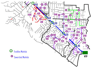
Establish a system that will allow for future line extensions and the addition of manholes that have been "lost" due to paving or being buried under easements. One approach to support flexibility is to number manholes in increments of ten.
As shown in Figure 1, the manhole numbers in sub-area 1 begin with 110 and continue by 10s (e.g. 120, 130, 140). A new manhole or connection between 120 and 130 can be assigned the number 121 and thus be logically incorporated into the existing numbering system.
Use IDs to Indicate Flow Direction
It's often important to know which manhole is upstream or downstream from another. Beginning your numbering system at the outlet point (e.g., the wastewater treatment plant, an outfall, or at the point of connection to the downstream community) and increasing the numbers as the system gets further from the outlet, ensures that the direction of flow can be quickly identified. When lower numbers are nearest the outlet, crews can have immediate guidance on direction of flow and where to look for a structure in each service sub-area.
For more information about manhole identification, contact Gina Snyder at snyder.gina@epa.gov or (617) 918-1837.