| Site Photos |
| Site photos not available |
| Site Information |
| Site ID |
WEL149 |
| Site name |
Wellston |
| County |
Wexford |
| State abbreviation |
MI |
| Latitude; decimal degrees |
44.2249 |
| Longitude; decimal degrees |
-85.8198 |
| Elevation; m |
295 |
| Operating agency |
EPA |
| Start date |
05/24/1988 |
| End date |
10/10/2000 |
| Primary Land Use |
Forest |
| Terrain surrounding site |
Flat |
| NADP/NTN site ID |
MI53 |
| Distance to nearest NTN site; km |
.123 |
| View Map |
View Map |
|
| Graphical Results |
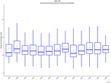
| Trend in maximum 8-hour average ozone concentrations |
 |
|
