| Site Photos |
| Site photos not available |
| Site Information |
| Site ID |
RCK163 |
| Site name |
Reynolds Creek |
| County |
Owyhee |
| State abbreviation |
ID |
| Latitude; decimal degrees |
43.21 |
| Longitude; decimal degrees |
-116.75 |
| Elevation; m |
1198 |
| Operating agency |
EPA |
| Start date |
05/12/1989 |
| End date |
09/28/1993 |
| Primary Land Use |
Range |
| Terrain surrounding site |
Rolling |
| NADP/NTN site ID |
ID11 |
| Distance to nearest NTN site; km |
.567 |
| View Map |
View Map |
|
| Graphical Results |
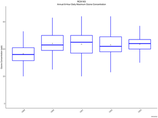
| Trend in maximum 8-hour average ozone concentrations |
 |
|
