| Site Photos |
| Site photos not available |
| Site Information |
| Site ID |
PAR207 |
| Site name |
Parsons Collocated |
| County |
Tucker |
| State abbreviation |
WV |
| Latitude; decimal degrees |
39.090434 |
| Longitude; decimal degrees |
-79.661742 |
| Elevation; m |
510 |
| Operating agency |
EPA |
| Start date |
02/23/1989 |
| End date |
09/07/1990 |
| Primary Land Use |
Forest |
| Terrain surrounding site |
Complex |
| NADP/NTN site ID |
WV18 |
| Distance to nearest NTN site; km |
.091 |
| View Map |
View Map |
|
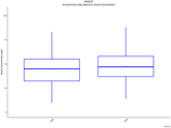
| Graphical Results |
| Trend in maximum 8-hour average ozone concentrations |
 |
|